PDF Attached
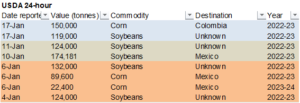
Private exporters reported the following sales activity:
-150,000 metric tons of corn for delivery to Colombia during the 2022/2023 marketing year; and
-119,000 metric tons of soybeans for delivery to unknown destinations during the 2022/2023 marketing year.
Grains and the soybean complex rallied from broad base buying, bottom picking, soybean product supply concerns post NOPA crush, Russian grain reserve comments hinting to a possible reduction in exportable supplies, higher WTI crude oil and Argentina production concerns.

World Weather, INC.
MOST IMPORTANT WEATHER FOR THE COMING WEEK
- Not much change occurred overnight
- Heavy snow is expected from northeastern Colorado through Nebraska into Iowa tonight and Wednesday causing travel delays and stressing some livestock
- Snowfall of 4 to 10 inches will be common with local totals over 12. Inches
- Moisture content into the snow will vary from 0.35 to 0.85 inch with a few areas to get nearly 1.00 inch of moisture
- Some rain is also expected along the southern and eastern portions of the precipitation event
- U.S. hard red winter wheat production areas are expecting three weather disturbances in the next ten days, but the southwestern portions of the region may not get much relief from drought
- First storm was noted above and may impact mostly northeastern Colorado and Nebraska with a little rain and snow in northern and eastern Kansas as well
- Second storm may be a disappointment this weekend as showers of rain and snow move through the central Plains producing another trace to 0.30 inch of moisture
- Third storm is expected during mid-week next week and it will attempt to bring some moisture to southern portions of hard red winter wheat country with 0.05 to 0.60 inch of moisture resulting
- The bottom line will remain one of concern over ongoing dryness in hard red winter wheat country, though there will be opportunities for precipitation later this winter and into early spring
- Most of U.S. hard red winter wheat country was dry during the Friday through Monday period, although some light precipitation occurred sporadically in Nebraska where up to 0.10 inch of moisture resulted
- Weekend storms continued to produce rain in much of California and in areas near and west of the Cascade Mountains in Washington and Oregon
- Moisture increases were impressive with 1.00 to 4.00 inches of rain occurring in coastal areas of while up to 6.00 inches occurred at Blue Canyon, California
- California’s active weather pattern is winding down with just two additional waves of light precipitation expected this week
- As of today, snow water equivalents in the Sierra Nevada is at the April 1 normal in the north, 121% of normal in central areas and 142% of that same normal in the south
- Relative to today, snow water equivalents vary from 209-288% of normal
- The break in the precipitation will help reduce flood potentials and give recent moisture a chance to soak into the ground, but more rain and snow will be needed to seriously raise water supply over that of recent past years and to curb this multi-year drought
- Florida citrus areas experienced cold temperatures Sunday and Monday mornings
- Most low temperatures were in the 30s, but several upper 20-degree readings were noted as well Sebring being one of the locations with such coolness
- Irrigation, wind machines and portable heaters were used to help keep the air temperatures above the damage threshold
- World Weather, Inc. believes very little damage occurred and no further losses were suspected to this year’s citrus crop
- U.S. Midwest, Delta and southeastern states will experience a frequent occurrence of rain and some snow (mostly in the Midwest) during the next couple of weeks maintaining and, in some cases, improving topsoil moisture for use in the spring
- U.S. Northern Plains and Canada’s Prairies will experience light amounts of precipitation during the next ten days to two weeks
- Snow cover remains significant in central and eastern North Dakota, Minnesota and in random locations across central and especially far eastern South Dakota
- Snow-free conditions are present in portions of the southwestern Canada Prairies and in portions of both Montana and western South Dakota
- Snow cover in Canada is greatest near the U.S. border in Manitoba and across the northern most portions of crop country
- Concern will rise over some of the drier areas in southwestern Canada where drought has lasted six years in some areas
- U.S. temperatures will turn colder next week while this week’s readings are near to below normal in the western states and above normal in the central and east
- Temperatures in the last week of this month will be cooler than usual in the central and western states with emphasis on the north-central states and south-central Canada
- West Texas and South Texas precipitation during the next ten days to two weeks will be restricted
- Totally dry conditions are not likely, but the moisture that occurs will tend to be sporadic and light offering no lasting improvements to soil moisture
- Eastern Argentina, Uruguay and Rio Grande do Sul rainfall will continue to be restricted over the next ten days to two weeks
- Totally dry weather is not likely, but inadequate rainfall for countering evaporation is most likely except possibly northern Rio Grande do Sul where some greater rain is possible
- Southwestern half of Argentina will get rain Friday and Saturday with 0.50 to 1.50 inches and several totals of 1.50 to more than 2.00 inches
- The moisture will favor the southwest half of Buenos Aires, La Pampa, San Luis and portions of western and southern Cordoba
- Argentina will get a few more showers during mid-week this week and again in the second half of next week, but each of these episodes of precipitation will result in only light amounts of rain with little lasting change in soil moisture
- Argentina’s next larger rain event after the end of this week will be possible again at the end of this month and confidence is low
- Temperatures in Argentina will become very warm to hot again this week ahead of the late week rainfall
- Argentina’s bottom line remains one of concern, though the Friday and Saturday rain event will provide some significant relief. Improvements in corn, sorghum, soybean and peanut crops will result. Early season corn and sunseed production may not change much due to the lateness of the season, but some improvement will be possible. Late season crops have the most to gain from timely rainfall, but the precipitation must occur routinely through the balance of the summer season to ensure the best yields. The frequency of the most significant rain in Argentina is not expected to be high enough for a serious turnaround in production, but rain will help to slow or stop the fall in production – at least for a little while.
- Brazil weekend precipitation varied widely with some areas getting more rain than others
- Some net drying occurred in a number of areas, but crop moisture in general was still rated favorably since many areas in center south crop areas were a little too wet last week
- Temperatures were seasonably mild to warm
- Rain in northern Rio Grande do Sul was most welcome with Paso Fundo reporting 3.20 inches
- Brazil weather will change little over the next two weeks with periodic rain occurring between periods of sunshine resulting in a good mix of weather for nearly all forms of crop development and fieldwork.
- Temperatures will continue to be mostly in a seasonably mild to warm range
- Portions of Rio Grande do Sul will have the greatest need for additional moisture
- India rain potentials are improving for a few north-central and many eastern winter crop areas next week
- The moisture will favor wheat, winter rice and some pulse production areas, but may not impact rapeseed production areas
- Rainfall will be light and the need for follow up rain will be high except from parts of Uttarakhand into Jammu and Kashmir where frequent precipitation of significance is expected
- Eastern Australia summer crop areas will begin experiencing periodic showers and thunderstorms during the weekend and especially next week
- The rain will help improve dryland sorghum, cotton and other crops
- Eastern China’s precipitation will resume in the Yangtze River Basin this weekend and especially next week
- The moisture will help maintain a very good outlook for future rapeseed and minor wheat production areas
- Some rain and snow will also impact the rest of the nation, but resulting moisture will not be great enough for serious changes to soil moisture
- North Africa will begin receiving routine bouts of rain in northern Algeria and coastal Tunisia this week with the precipitation continuing into next week
- The moisture boost will be ideal for improving wheat and barley establishment and raising the potential for better performance in the spring
- Some rain will also fall in northern Morocco, but southwestern Morocco and interior parts of Tunisia are expected to miss most of the significant rain resulting in ongoing dryness
- Europe will encounter and active weather pattern this week from Italy into the Balkan Countries as well as in northern Spain and western and southern France
- Flooding rain is possible in northern Spain, southern Italy and in the western Balkan region with emphasis on the eastern Adriatic Sea region
- Some of these areas will receive 3.00 to more than 7.00 inches of rain by the weekend
- Europe’s North and Baltic Sea regions will receive the least significant rain during the next ten days, although the region will not be totally dry
- Some coastal areas of Norway, Sweden and the U.K. may receive some moderate to locally heavy rainfall
- Far western Russia, Belarus, western Ukraine and the Baltic States are expecting frequent snow and rain events into Saturday and then some drier weather is expected
- Most other areas in Russia and Ukraine will be dry
- South Africa will be mostly dry early this week as it was during the weekend
- Some rain is expected to evolve in the second half of this week favoring the south-central and southeastern crop areas for a while
- Some heavy rain may evolve briefly in Eastern Cape and especially southwestern Natal
- Limpopo, Mpumalanga and eastern Nata will be last to get rain, but some may evolve next week
- Greater rain is expected in western Free States, far western Northwest and eastern portions of Northern Cape during the week next week, though confidence is a little low on how significant that may become
- Southeast Asia (Indonesia and Malaysia in particular) will experience slowly increasing rain frequency and intensity in the next week to ten days
- Weekend precipitation was erratic and sometimes very light
- Philippines rainfall has been heavy at times in eastern production areas of the nation this winter due to a strong northeast monsoon flow
- Heavy rain fell during the weekend from Samar Island north into southeastern Luzon Island where some areas reported 4.00 to more than 7.00 inches
- Flooding has been most significant in Samar recently, although there has been some flooding in eastern Mindanao as well as southeastern Luzon as well
- The unsettled weather will continue this week
- Some forecast models suggest a tropical cyclone may evolve and threaten Mindanao this weekend, but confidence is low
- Lower coastal areas of Vietnam may receive some heavy rain again next week, though this week’s precipitation will be lighter and less threatening
- Western Turkey will continue to receive frequent rain over the next ten days with some mountain snow
- Central and eastern Turkey will be drier biased, although not completely dry
- Middle East rainfall is expected to be erratic over the next couple of weeks with only pockets of significant moisture
- Northern Iraq and southwestern Iran may be wettest, although Syria may become wetter early next week
- The remainder of Iraq and much of Iran will only receive brief bouts of very light precipitation
- East-central Africa precipitation is expected to be abundant in Tanzania over the next ten days to two weeks while that which occurs in Uganda, southwestern Kenya and Ethiopia is more sporadic and lighter.
- Coffee and cocoa conditions should remain favorable in all production areas, despite the anomalies
- West-central Africa dryness will continue through the next ten days to two weeks
- Dry conditions are normal at this time of year
- No excessive heat is expected in this coming week, although warmer than usual conditions are expected into the first days of February
- Rain will occur near the coast only
- Today’s Southern Oscillation Index has peaked and it has begun a period of more significant decline. The index today was still at +18.84 after peaking at +21.45 last Wednesday
Source: World Weather and FI
Bloomberg Ag calendar
Tuesday, Jan. 17:
- USDA export inspections – corn, soybeans, wheat, 11 am (10 am CT)
- NOPA 12 pm (11 am CT)
- China 4Q pork output and inventory levels
- New Zealand global dairy trade auction
- EU weekly grain, oilseed import and export data
Wednesday, Jan. 18:
- Global Forum for Food and Agriculture, Berlin, Jan. 18-21
- Asia 4Q 2022 cocoa grinding data
Thursday, Jan. 19:
- European cocoa grindings
- North America cocoa grindings
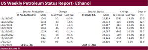
- EIA weekly US ethanol inventories, production
- Port of Rouen data on French grain exports
- New Zealand Food Prices
- USDA red meat production, 3pm
Friday, Jan. 20:
- Malaysia’s Jan. 1-20 palm oil exports
- ICE Futures Europe weekly commitments of traders report
- CFTC commitments of traders weekly report on positions for various US futures and options
- US net- export sales for corn, soybeans, wheat, cotton, pork and beef, 8:30am
- US cotton ginnings
- US cattle on feed
Source: Bloomberg and FI
USDA inspections versus Reuters trade range
Wheat 320,473 versus 150000-400000 range
Corn 774,461 versus 400000-700000 range
Soybeans 2,075,197 versus 900000-1925000 range
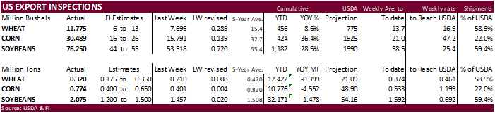
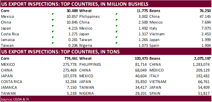
GRAINS INSPECTED AND/OR WEIGHED FOR EXPORT
REPORTED IN WEEK ENDING JAN 12, 2023