PDF Attached
USDA
report day.
Wednesday:
MPOB (comes out tonight for Americas)
Thursday
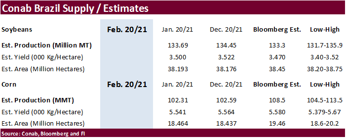
Conab
USDA
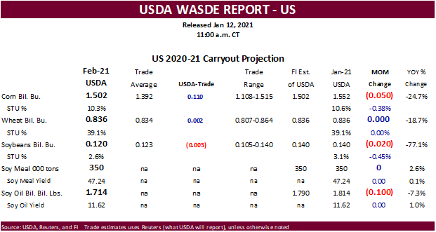
released their February S&D.
Reaction:
Perceived
bearish with corn and soybeans that were already trading higher pre report. Wheat on the other hand is seen supportive, for traders following global inventories. US corn stocks were well above trade expectations, but China remains the million dollar question
with final current crop year imports.
Recall
last S&D report CBOT corn traded limit higher. Nearby hit session lows post report. February USDA supply and demand report traditionally is a benign report. USDA made US demand adjustments this month to accommodate global trade flows, notably corn, despite
no 2020-21 production changes for Argentina and Brazil corn and soybean estimates. Note overnight China left their corn and soybean S&D’s unchanged. But USDA has a differs view on China corn imports as they raised it by 6.5 million tons to a record 24 million
tons.
We
wonder if the next round of large buying by China wheat will be.
Major
changes
China
corn imports were upward revised 6.5 million tons to 24 million tons.
USDA
upward revised US soybean exports by 20
US
SBO for biodiesel use up 100
US
corn exports up only 50
No
change to US wheat (ALL) balance, but notable by class below
Big
drop of 9.0 million tons for world wheat stocks
World
corn stocks up 2.7MMT and soybeans down 1.0MMT.
USDA
NASS executive summary
https://www.nass.usda.gov/Newsroom/Executive_Briefings/index.php

Weather
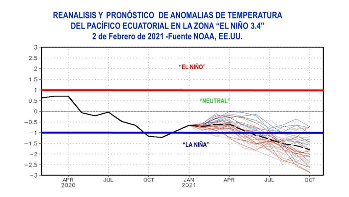
Argentina’s
exchange released an email updating La Nina prospects through October
MOST
SIGNIFICANT WEATHER AROUND THE WORLD
- Northwestern
Ukraine, southeastern Belarus and west-central Russia will experience heavy snow and blizzard conditions late this week and into the weekend with 12-20 inches of snow from a single storm - Livestock
stress and travel delays are likely - Bitter
cold will follow the event, but winter grains will be adequately protected from the cold - Snow
will continue to fall over many areas in eastern Europe and the western CIS during the next ten days keeping snow cover present to protect most winter crops from damaging cold - Russia’s
Southern region will also get some snow, but temperatures are not currently expected to be low enough to threaten crops in the near term - Flood
potentials remain high in western Europe due to saturated soil and frequent ongoing bouts of precipitation - No
large storms are expected in the coming week, but the following week may trend a little stormier - North
Africa will continue to experience erratic rainfall - Dryness
remains a concern in southwestern Morocco and northwestern Algeria with favorable conditions in most other areas - Winter
crops are semi-dormant and do not have much need for precipitation now, but greater precipitation will be needed in a few weeks as spring growth begins - India
may get some welcome precipitation in the central and southeast parts of the nation next week, but the coming seven days will remain mostly dry - Any
precipitation would be welcome for winter grain, oilseeds and pulse crops - Sugarcane
and rice would also benefit from the precipitation - Eastern
Australia weather still looks highly favorable in New South Wales where a mix of rain and sunshine is supporting many crops especially the irrigated cotton and sorghum - Little
change in the current trend is expected for the next two weeks - Queensland,
Australia will receive some important rainfall as scattered showers and thunderstorms during the next two weeks - Portions
of the state’s grain and cotton areas will not get enough rain to seriously bolster soil moisture, but other areas will see a good mix of weather - Irrigated
crops are in the best conditions and will remain that way - Argentina
weather Monday - Temperatures
Monday were mild in the southwest half of the nation with highs in the 70s Fahrenheit with a few 60s in San Luis and southern Cordoba - The
cool air was very helpful in conserving soil moisture through lower evaporation - Temperatures
were seasonably warm in the northeast where highs in the 80s and lower to a few middle 90s Fahrenheit were noted - Rainfall
was confined to San Luis, a few far western Cordoba locations and in portions of Santiago del Estero where amounts varied up to 0.79 inch - Argentina
will continue to experience restricted rainfall from La Pampa and western Buenos Aires into Santa Fe and southeastern Cordoba over the next ten days - Any
showers that occur (and there will be some) will be brief and light failing to counter evaporation, but will they will help slow the drying trend - Rain
will be a little more significant periodically in eastern Buenos Aires, Entre Rios and northern parts of Argentina; including Santiago del Estero and a few western Cordoba locations - Temperatures
will be seasonable - Most
crops in the nation will remain in favorable condition for the coming week due to either favorable subsoil moisture or due to timely rainfall. Some drying is expected and a rise in crop stress is probable for the drier areas noted above, but critically dry
conditions are not expected in this first week of the outlook. World Weather, Inc. still believes late February rainfall will increase in time to maintain a favorable – not ideal – outlook for summer crop development.
- Brazil
weather Monday was good for soybean and early corn maturation and harvest progress - Rain
was limited to Minas Gerais and a few neighboring areas while dry and warm conditions occurred to the west and south - Aggressive
fieldwork likely occurred - High
temperatures were in the 90s Fahrenheit in Mato Grosso which helped to accelerate drying and perpetuate fieldwork - Highs
in the 80s and lower 90s occurred in many other areas with some 70s in Minas Gerais and parts of both Espirito Santo and Rio de Janeiro - Brazil
weather is still expected to be favorably mixed over the next two weeks with alternating periods of rain and sunshine supporting crop maturation and fieldwork as well as supporting normal crop development - Rain
may fall a little more often than desired in several areas, but the pattern will not be anomalously wet enough to induce a serious crisis in fieldwork - Some
areas will need drier weather while others will experience sufficient drying time to support favorable advancements in the planting of Safrinha crops and the harvest of soybeans - South
Africa weather will include some net drying for a while especially in western crop areas - Most
of the nation was dry Monday - Rain
is possible periodically as scattered showers across the nation, but resulting amounts will be light - Natal
and some neighboring areas will be wettest Friday through the weekend with some heavy rainfall near the coast - Temperatures
will be seasonable with a warm bias in the west - Indonesia,
Malaysia and Philippines weather is expected to be varied over the next ten days with periods of rain expected – most of which will be light intensity - Some
locally moderate rain will be possible - Heavy
rain may impact a part of the east-central and southeastern Philippines in the February 17-23 period
- Northern
Laos, northern Vietnam and immediate neighboring areas received 1.00 to 2.25 inches of rain Monday and early today - The
moisture was welcome for winter crops, but it may have induced some coffee flowering in the north of Vietnam - Showers
from the same disturbance will move south through the remainder of Vietnam, Cambodia, Laos and eastern Thailand today and early Wednesday before dry weather resumes - Rainfall
today and early Wednesday will be much lighter than that of Monday and should not cause much concern for coffee flowering in Vietnam’s Central Highlands - Rain
in other areas will be good for winter crops - The
return of drier weather will be equally welcome since seasonal rainfall does not begin in the mainland areas of Southeast Asia until March normally - Much
needed rain will fall in southern China today and Wednesday impacting areas from Guangxi and Guangdong to Fujian and Zhejiang - These
provinces are quite dry and considered to be in various stages of drought, according to the China Meteorological Department - The
rain will be welcome and should range from 0.75 to 1.50 inches with a few amounts over 2.00 inches, but drought status will remain
- Greater
rain is needed in the next few weeks to support improved rice and corn planting conditions and to stimulate improved sugarcane and citrus development - China
temperatures have been warmer than usual in recent days, but did trend a little cooler Monday - The
warmth has stimulated a little rapeseed development in the south, but no aggressive plant development is expected for a while - Temperatures
will remain a little warmer than usual, but still cool enough to keep development in check for a while - No
threatening cold will occur in the nation’s wheat or rapeseed areas for the next ten days, although the northeast will trend colder next week - Bitter
cold will continue in North America through the weekend with some moderation in temperatures Sunday into early next week - Some
of the coldest air will push through a part of the U.S. Midwest this weekend and early next week before retreating into eastern Canada - Waves
of snow will continue while the bitter cold is in place and that snow will be extremely important for winter wheat in the Midwest and central Plains - No
winterkill is expected in soft wheat areas in the Midwest or in hard red winter wheat production areas - Snow
free areas in the northern Plains and a part of Saskatchewan might have induced winterkill for some minor wheat production areas in recent days and the losses are not expected to expand much further - These
are minor wheat production areas relative to the nation’s entire crop, although a few counties in South Dakota may lose some of their crop and that area does produce more winter wheat than North Dakota
- Heavy
snow will evolve from South Dakota and eastern Wyoming southward into northern Texas and east into the central and western Midwest Friday through Sunday - Accumulations
of 2 to 6 inches will occur in South Dakota while 4 to 10 inches occur in the central Plains and 5 to 12 and local totals over 14 inches may impact a part of the Midwest - Snowfall
in the southwestern Plains will vary from a trace to 4 inches while parts of Oklahoma will get 4 to 8 inches - Moisture
content in the snow will be low in the Plains and probably will not impact drought status much, but the moisture will be greater in the Midwest where some minor flood potentials will rise as spring approaches - River
icing on the upper Mississippi, upper and middle Missouri and Illinois Rivers will continue over the next several days slowing or shutting down barge traffic for a while - U.S.
Delta and southeastern states will experience waves of rain and some snow, freezing rain and sleet over the next ten days maintaining wet field conditions and inducing some travel delay while stressing livestock - U.S.
livestock stress will continue significant across the northern and central Plains and upper Midwest through the weekend and into early next week with some increase in animal stress in the southwestern Plains for a little while this weekend as well - Milk
production could slip lower and animal weight gains may be slow - There
will be some risk of animal death or injury because of the bitter cold, snow and extreme wind chills - U.S.
northwestern states will see waves of snow and rain from mid-week this week through next week, but the precipitation will be greatest along the coast and in the mountains - Drought
status is not likely to change much in the interior western states - U.S.
northern Plains drought will not be changed over the next week to ten days, despite some bouts of light snow from Montana to South Dakota - The
same is true for Canada’s eastern and southern Prairies drought - East-central
Africa rainfall will be erratic and mostly light each day through the next two weeks - Tanzania
will receive the greatest rain and experience the greatest daily coverage - A
few showers and thunderstorms will occur periodically in Ethiopia, Kenya and Uganda - West
Africa rainfall will remain mostly confined to coastal areas while temperatures in the interior coffee, cocoa, sugarcane, rice and cotton areas are in a seasonably warm range for the next ten days - There
is potential for a few of the showers to reach northward into coffee and cocoa production areas of Ivory Coast and Ghana next week, but resulting rainfall should be light - Some
showers were noted in western Nigeria crop areas briefly Monday - Southern
Oscillation Index weakened during the weekend and this trend will continue this week - Today’s
SOI was +14.71 today and the index will continue to rise for a little while this week - Mexico
precipitation this week and next week will be mostly confined to the east coast
- The
precipitation will be erratic and mostly light, but still welcome wherever it occurs - Many
areas in Mexico are still dealing with long term drought - Central
America precipitation will continue greatest along the Caribbean Coast and in Guatemala while the Pacific Coast is relatively dry - Canada
Prairies will be much colder than usual into the weekend and then “some” warming is expected for a while late this weekend and next week - Temperatures
are not likely to become warmer than usual, but may rise a little closer to normal for a while - Bitter
cold conditions have been threaten unprotected wheat and livestock - Some
wheat damage has occurred in Saskatchewan and livestock stress has been extremely high - Southeast
Canada will experience less than usual precipitation and some colder biased conditions this week
Source:
World Weather Inc. and FI
- USDA’s
monthly World Agricultural Supply and Demand (WASDE) report, noon - (CASDE
?) - France
agriculture ministry updates 2021 winter-crop planting estimates
Wednesday,
Feb 10:
- EIA
weekly U.S. ethanol inventories, production, 10:30am - Malaysian
Palm Oil Board data on January palm oil end- stocks, output, exports - Malaysia
Feb. 1-10 palm oil export data from AmSpec, Intertek, SGS - FranceAgriMer
monthly grains report - HOLIDAY:
Vietnam
Thursday,
Feb 11:
- USDA
weekly crop net-export sales for corn, soybeans, wheat, cotton, pork, beef, 8:30am - Conab’s
data on yield, area and output of corn and soybeans in Brazil - Russian
consultant IKAR holds agricultural conference, day 1 - Port
of Rouen data on French grain exports - HOLIDAY:
China, Japan, South Korea, Vietnam
Friday,
Feb 12:
- ICE
Futures Europe weekly commitments of traders report, 1:30pm (6:30pm London) - CFTC
commitments of traders weekly report on positions for various U.S. futures and options, 3:30pm - Russian
consultant IKAR holds agricultural conference, day 2 - New
Zealand Food Prices - HOLIDAY:
China, Hong Kong, Indonesia, Malaysia, South Korea, Singapore, Vietnam, Thailand, Philippines
European
Crude And Oil Products Stocks At 1.161 Bln Barrels In Jan, Up 0.5% From Dec, Up 4.5% Y/Y – Euroilstock
–
European Crude Oil Stocks At 483.41 Mln Barrels In Jan, Down 0.8% From Dec, Up 2.9% Y/Y
–
European Gasoline Stocks At 118.49 Mln Barrels In Jan, Up 1.3% From Dec, Down 0.7% Y/Y
–
European Middle Distillates Stocks At 461.18 Mln Barrels In Jan, Up 1.5% From Dec, Up 8.3 % Y/Y
US
EIA Raises Forecast For 2022 World Oil Demand Growth By 190K Bpd, Now Sees 3.50 Mln Bpd YoY Increase
–
Cuts Forecast For 2021 World Oil Demand Growth By 180K Bpd, Now Sees 5.38 Mln Bpd YoY Increase
–
2021 World Oil Demand Growth Unchanged At 5.56 Mln Bpd YoY Increase
–
2022 World Oil Demand Growth Unchanged At 3.31 Mln Bpd YoY Increase
Corn.
-
Corn
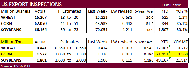
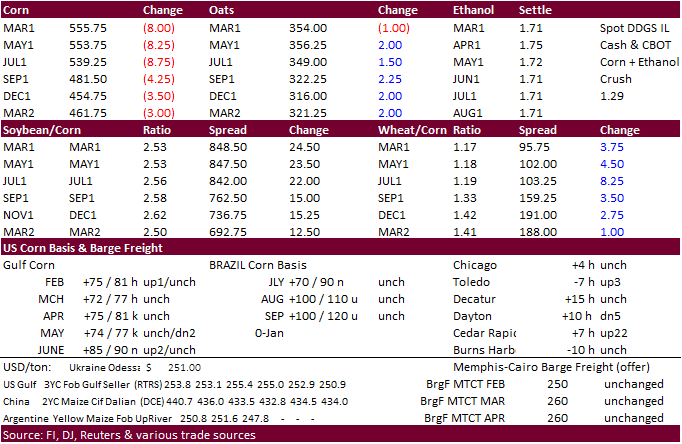
futures were lower as expected as futures money managed positions were already unusually high. Prices are not out of reach for new high though. China needs to import a record amount of US corn inspections which is not out of reach.
-
Meanwhile
China’s AgMin warned domestic corn prices are expected to remain high in 2020-21 from strong demand in the livestock sector.
-
Goldman
roll – day 3. Spreads were again active but more so USDA S&D report related, IMO.
-
Algeria
reported a H5N8 bird flu outbreak. -
A
Bloomberg poll looks for weekly US ethanol production to be unchanged at 936,000 barrels (929-941 range) from the previous week and stocks up to 181,000 barrels to 24.497 million.
Corn
Export Developments

Updated
2/9/21
March
corn is seen trading in a $5.30 and $6.00 range. (up 15, unch)
May
corn is seen in a $5.15 and $6.00 range. (up 15, unch)
July
is seen in a $5.00 and $6.00 range. (up 10, up 25)
December
corn is seen in a $3.75-$5.50 range. (no change)
