PDF Attached
Another
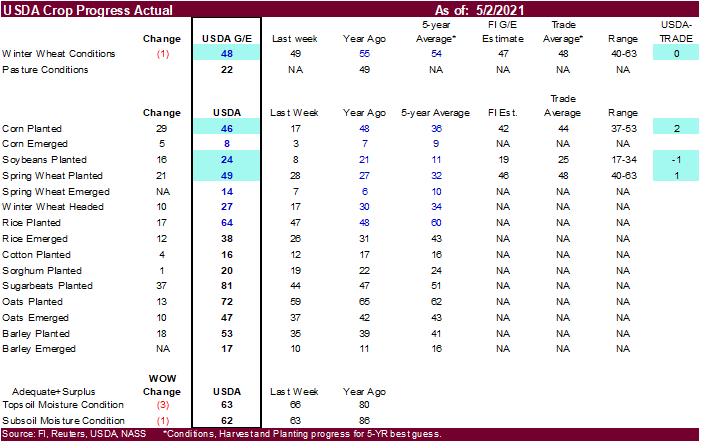
choppy trade from what appears to be lack of direction. US weather is improving. Brazil corn production downgrades are supportive feedgrains. US crop progress was around expectations but don’t discount pressure in corn on Tuesday as the US should be nearing
50 percent complete by Wednesday.
Past
7 days
Next
7 days
World
Weather, Inc.
WEATHER
TO WATCH THIS WEEK
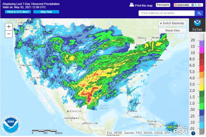
- Some
beneficial rain fell from eastern Nebraska through west-central and northeastern Iowa to Wisconsin during the weekend - Moisture
totals of 0.30 to 1.25 inches occurred most often with Doppler radar suggesting some locally heavy amounts of rain - The
precipitation was welcome with more needed - No
relief to dryness occurred in southern Minnesota, northwestern Iowa or neighboring areas of northeastern Nebraska where rain is needed to ease developing dryness - Portions
of Iowa, southeastern South Dakota, northeastern Nebraska and southern Minnesota reported excessive heat during the weekend in the very same area that has been unusually dry in the past 30 days - Extreme
high temperatures reached into the 90s with Spencer, Iowa reporting 97 degrees Fahrenheit; most extreme highs were in the lower 90s - Crops
and livestock were stressed by the heat and rapid soil moisture depletion resulted - Frost
and freezes are likely in the Dakotas and western Minnesota tonight and in the upper Midwest Tuesday night into Wednesday morning - The
cold may damage a few early emerged and developing spring crops - Some
frost may occur into parts of Iowa and Nebraska, but damage to crops should not be significant in those areas.
- A
little frost may also occur in western Kansas, eastern Colorado and neighboring areas of the west-central high Plains tonight - Most
temperatures will not be low enough to permanently harm wheat - Excessive
rain fell across portions of Texas during the weekend resulting in some flooding - The
southern Blacklands and the middle and upper Texas coast were wettest with 2.00 to 4.13 inches common and local amounts along the central coast getting over 7.00 inches - Victoria
reported 7.64 inches - A
few rice production areas were flooded, and a few corn, sorghum and cotton areas were impacted by heavy rain, but much of the rain was not problematic except that which occurred near the coast - Southeastern
parts of West Texas received additional rain Friday with amounts of 0.05 to 0.30 inch noted after greater rain fell during mid-week last week - Much
of West and far South Texas still have need for significant rain - A
few showers and thunderstorms are possible today and again Friday into Saturday - The
precipitation may not generate much beneficial moisture, but it and that which has occurred prior to that time is adding some moisture to the air which should help improve the potential for greater rain when conditions are right later this spring - Rain
is still advertised in southwestern and far southern Alberta and southwestern Saskatchewan as well as the northern U.S. Plains this weekend - No
general soaking is expected, but 0.15 to 0.60 inch and local totals to nearly 1.00 inch will be possible and that could go a very long way in improving spring planting and establishment conditions - Coverage
of the greatest rain will not be widespread, but improvement is expected wherever more than 0.40 inch of moisture results - The
remaining Prairies and northeastern Plains may not be impacted by much precipitation and drought conditions will prevail - U.S.
Midwest, Delta and southeastern states will experience alternating periods of rain and sunshine during the next ten days keeping field progress a little slow but assuring a good start to emergence and establishment.
- Iowa
will get some additional relief from dryness along with a few neighboring areas later this week and into next week
- Amounts
will be light varying 0.20 to 0.80 inch and locally more - The
greatest rainfall this week is expected in the lower Midwest where some moderate to heavy rain may occur periodically. Some field working delay is expected, but progress was likely good in many areas during the weekend - Upper
Midwest precipitation will be lightest in this coming week and a close watch on next week’s precipitation potential is warranted - The
GFS model is much wetter than the European model for the upper Midwest, northern Plains and Canada’s Prairies for the coming weekend and early next week - U.S.
Southeastern states will experience a good balance between rain and sunshine over the next ten days - U.S.
Delta could be a little too wet at times in the coming week slowing field progress at times - U.S.
Midwest, northern Plains and eastern Canada’s Prairies weather will be cooler than usual this week - Warmer
than usual weather will occur in the southwestern United States - Next
week will trend a little warmer in the Plains and lower Midwest - Interior
U.S. Pacific Northwest will remain drier biased over the next two weeks with near to below average temperatures this week - Brazil
rainfall during the weekend was greatest in eastern Mato Grosso where 0.50 to nearly 2.00 inches resulted; most other crop areas in the nation were dry and temperatures were seasonable
- A
few showers occurred in central Mato Grosso do Sul and from northern Rio de Janeiro to eastern Bahia, but crop areas failed to get more than 0.25 inch of moisture - Highest
afternoon temperatures were in the 70s and lower 80s Fahrenheit in southern Safrinha corn production areas while in the 80s and lower to a few middle 90s in the north - Brazil
is facing another ten days to two weeks of dry weather in its Safrinha corn and cotton areas along with its sugarcane, coffee and citrus areas - Most
of the drying is normal for this time of year, but soil conditions are already quite dry and reproducing and filling Safrinha crops will suffer enough stress to hurt production - Brazil
rainfall will be mostly confined to the far northern fringes of crop country and in Rio Grande do Sul for the coming ten days - Crops
in Rio Grande will benefit greatly from alternating periods of rain and sunshine - Argentina
weather was also mostly dry during the weekend with temperatures near to above average - A
few showers did occur in Buenos Aires overnight with rainfall to 0.39 inch through 0100 CDT today - An
extreme low of 35 Fahrenheit occurred in the interior southeast which might have been low enough for a patch or two of frost - Crop
damage if any should have been minimal - Argentina
rainfall through Wednesday will be sufficient to maintain moisture abundance for late season crop development - Amounts
will vary from 0.20 to 0.60 inch with local totals of up to 1.50 inches and a little more - Buenos
Aires and areas from northern Uruguay to central Santa Fe and southeastern Santiago del Estero will be wettest - Argentina
will be dry Thursday through Monday with another chance for rain during mid-week next week
- The
bottom line will be very good for late season crops, although a little less rain might be best for late season summer crop maturation and harvest progress - The
moisture will be good for winter wheat planting late this month and in June - Another
period of drying will occur late next week through May 17. - Argentina
temperatures will be a little cooler this week, but only slightly below average - Some
frost is possible in southern La Pampa and far southwestern Buenos Aires Tuesday and in the traditionally coolest areas of southeastern Buenos Aires Wednesday - Temperatures
should stop short of being damaging to immature soybeans and other crops, but the situation will be closely monitored - Europe
will receive waves of rain this week across some of the central and north improving topsoil moisture in some areas after recent drying - Southern
Europe will be drier this week - Temperatures
will be cooler than usual in the north and near to above normal in the south - Next
week’s weather will be wetter from northern Spain and Portugal through France to Poland, Slovakia and Hungary while a little drier farther to the north - Temperatures
will also be a little warmer in the north next week while cooler in the wetter areas - Europe
weekend precipitation was greatest from southeastern France and northern Italy through southeastern Germany and Austria to Poland where 0.40 to 1.00 inch was common and a few amounts of 1.00 to 2.40 inches
- More
limited precipitation occurred elsewhere - Temperatures
were in the 50s and 60s except in southeastern parts of the continent where 70s and 80s were noted - CIS
rainfall during the weekend was greatest in western Russia where amounts varied from 0.20 to 0.50 inch and local totals 0.84 inch - Temperatures
were warm enough to stimulate winter crop development in Ukraine and Russia’s Southern region and support planting in most of the same southern areas - Several
waves of rain will impact western Russia, Belarus, the Baltic States and in a few areas of northwestern Ukraine during the coming ten days maintaining wet field conditions
- Farming
activity will remain restricted in these areas with rising concern over delayed spring planting - Good
field progress will occur farther to the south where much less precipitation is expected, and temperatures will be more seasonable - Temperatures
will be cooler than usual in the wetter areas of the northwest. - Eastern
Russia New Lands will experience a dry and warm bias through the next two weeks - The
environment will eventually be great for spring planting - East-central
and southern China temperatures rose well above average during the weekend with highs in the 80s and lower to a few middle 90s Fahrenheit - Highs
in the North China Plain were in the 70s and 80s except in the fart northeast where 50s and 60s were noted - Highs
in northeastern China were also in the 50s and 60s - Very
little precipitation fell during the weekend allowing net drying to occur in many areas
- Thunderstorms
did evolve Sunday and early today from eastern Sichuan to Shaanxi and some of the rain was heavy - Some
heavy rain also occurred in southeastern Guangxi and western Guangdong - Fieldwork
likely advanced swiftly in the North China Plain and east-central provinces - North
China Plain weather will be limited on precipitation for the next couple of weeks and temperatures will be warming - A
steady decline in soil moisture is expected with temperatures trending warmer
- A
rising need for rain is expected later this month - Excellent
planting progress is anticipated for a while until dryness becomes more of an issue - Northeastern
China will experience slowly warming temperatures and infrequent precipitation allowing fieldwork to slowly increase - Southern
China rain will fall abundantly and frequently over the next couple of weeks limiting some farming activity and keeping the region saturated or nearly saturated - Some
local flooding will be possible at times - Australia
weather during the weekend was mostly dry and mild to warm with coastal showers only - Western
Australia will receive waves of rain through mid-week this week while other areas are mostly dry
- Total
rainfall will vary from 0.50 to 1.50 inches by Thursday afternoon with good coverage - The
moisture will support some early season wheat, barley and canola planting, but follow up moisture will be needed - A
few sporadic showers may occur in other areas, but resulting rainfall will not likely be very great except in the Great Dividing Range of the east
- Temperatures
will be near to above average - South
Africa received scattered showers during the weekend in nearly 60% of crop areas with moisture totals to 0.43 inch common and local totals to 0.62 inch in Mpumalanga and 1.38 inches in southeastern Free State eastern and southern Natal - Driest
in the west - Temperatures
were mild - South
Africa will receive some late season showers again Thursday into the weekend with net drying until then - Next
week will trend drier once again - The
environment will be good for harvesting and late season crop maturation - Production
this year has been very good for nearly all crops - Winter
wheat and barley planting should benefit from the moisture, although rain will soon be needed in the west - India
weather will remain good for winter crop maturation and harvest progress, although showers will continue periodically in some areas - Southern
India will be wetter than usual over the next couple of weeks and rain will also fall frequently from Bangladesh into the far Eastern States - Delays
to harvest progress will be greatest in the south - Showers
in northern India will not be great enough to be much of a factor to crop maturation or harvesting - No
tropical cyclones are present in the world today - Southern
Oscillation Index is mostly neutral at -.06 and the index is expected to slip a little lower over the next few days - Mexico
drought will continue during the next two weeks, although scattered showers will occur periodically in the east and far south with the south wettest.
- Next
week will be wetter than this week favoring the east half of the nation - Xinjiang
China’s cotton areas were left dry and turned hot briefly Friday and Saturday before cooling in the northeast Sunday - Highest
afternoon temperatures reached the 80s Fahrenheit in the northeast and the 90s west and south - Cooling
Sunday brought a few showers to the northeast, but most of the rain was not significantly and none of the cooler air reached the southwest - Improved
early season crop development conditions occurred, although the sudden warming from very cold conditions may have been stressful - Some
replanting of cotton may be necessary in the northeast after freezes occurred a week ago - Xinjiang,
China weather will remain war in the west and south while the northeast will see alternating periods of normal and above normal temperatures - Some
rain will occur infrequently in the northeast as scattered showers infrequently - The
moisture will have a low impact - There
is no risk of threatening cold temperatures, but some of the heat could stress early emerging crops in the southwest - North
Africa rainfall will receive erratic rainfall this week favoring Algeria and Tunisia where crop conditions will be good or getting better. Northwestern Algeria will see the lightest rain - Morocco
is not likely to see nearly as much rain and may experience net drying, but crops are in the best shape in northern Morocco and drying should not induce any harm.
- Southwestern
Morocco is still too dry, though - Temperatures
are trending warmer than usual - West-central
Africa rainfall was greatest in western Cameroon and eastern Nigeria during the weekend while net drying occurred in most other areas - A
favorable mix of rain and sunshine has been occurring recently and the trend will continue, although some of the precipitation will be lighter than usual leading some need for greater rainfall later this month - Crop
conditions will stay good - East-central
Africa rainfall has been erratic in recent weeks and a boost in rainfall is coming to Kenya, Ethiopia and northern Tanzania during the coming week - Southeast
Asia rainfall will be favorably distributed in Indonesia, Malaysia and most of the mainland areas during the next two weeks - Greater
rain is needed in the northern and western Philippines and in southern parts of central Vietnam and other mainland crop areas - New
Zealand precipitation for the next two weeks will be lighter than usual in North Island and eastern parts of South Island while moderate to heavy rain occurs long the west coast of South Island possibly inducing some flooding - Temperatures
were near to above average
Source:
World Weather, Inc.
Tuesday,
May 4:
- Purdue
Agriculture Sentiment - New
Zealand global dairy trade auction - EARNINGS:
Bunge, Andersons, Minerva - HOLIDAY:
Japan, China, Thailand
Wednesday,
May 5:
- EIA
weekly U.S. ethanol inventories, production - Malaysia
May 1-5 palm oil export data - New
Zealand Commodity Price - HOLIDAY:
Japan, China
Thursday,
May 6:
- FAO
World Food Price Index - USDA
weekly crop net-export sales for corn, soybeans, wheat, cotton, pork, beef, 8:30am - Port
of Rouen data on French grain exports
Friday,
May 7:
- China
customs publishes trade data, including imports of soy, edible oils, meat and rubber - ICE
Futures Europe weekly commitments of traders report (6:30pm London) - CFTC
commitments of traders weekly report on positions for various U.S. futures and options, 3:30pm - CNGOIC
monthly report on Chinese grains & oilseeds - Canada’s
Statcan to issue wheat, canola, barley and durum stockpile data - FranceAgriMer
weekly update on crop conditions
Source:
Bloomberg and FI
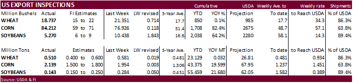
USDA
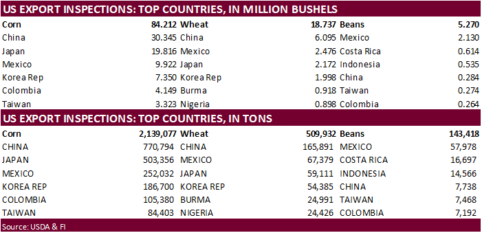
inspections versus Reuters trade range
Wheat
509,932 versus 400000-600000 range
Corn
2,139,077 versus 1100000-2150000 range
Soybeans
143,418 versus 150000-300000 range
US
Construction Spending (M/M) Mar: 0.2% (est 1.7%; prev R -0.6%)
US
Markit Manufacturing PMI Apr F: 60.5 (est 60.7; prev 60.6)
US
ISM Manufacturing Apr: 60.7 (est 65.0; prev 64.7)
–
Prices Paid: 89.6 (est 86.1; prev 85.6)
–
New Orders: 64.3 (est 69.5; prev 68.0)
–
Employment: 55.1 (prev 59.6)
Canadian
Markit Manufacturing PMI Apr: 57.2 (prev 58.5)
- Another
wild trading day in US agriculture futures with an extremely volatile close. After CBOT
corn
opened sharply higher, to fresh 8-year highs, prices tanked presumably on good US weather with the advancement of US corn seedings, then to rebound. CBOT corn margins were increased, so that could have triggered profit taking by longs and had some shorts
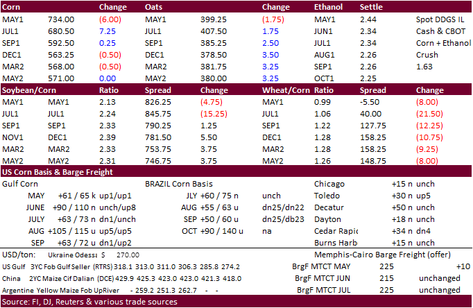
shore up positions. Note corn margins increased 35 percent since April 22. There was a good amount of action in selling nearby corn spreads.
As
of 1:20
- S/C
November/December price ratio declined to its lowest level since June 2020.
- US
corn plantings came in slightly above trade expectations. - Talk
of sub 100 million ton Brazil corn crop and follow through bullish momentum is supporting prices. US weather was very good over the past week with exception of some dry areas out west. Rule of thumb is that the lower the Brazil corn crop, greater US and
Ukraine corn exports. - StoneX
Brazil lowered their Brazil total corn production estimate to 100.25 million tons from 105.06 previous. 2nd crop corn was lowered to 72.7 million from 77.65MMT. Brazil soybeans are projected at 135.73MMT, up from 134.03MMT last month.
- Somar
in a note to Bloomberg said rain will be limited for Brazil’s Rio Grande do Sul state, in the next seven days.
- I’m
using 101 million tons for Brazil corn, down from 103MMT April 26 with second crop at 74.642 million tons.
- USDA
US corn export inspections as of April 29, 2021 were 2,139,077 tons, within a range of trade expectations, above 1,954,012 tons previous week and compares to 1,349,204 tons year ago. Major countries included China for 770,794 tons, Japan for 503,356 tons,
and Mexico for 252,032 tons. - Late
last week Safras & Mercado estimated the Brazil corn crop at 104.1 million tons, 8% below their previous forecast. Second crop corn was pegged at 70.7 million tons.
- On
Monday, the funds in corn were flat. - There
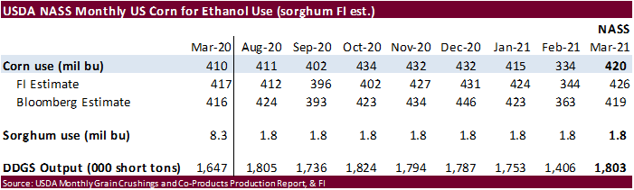
were no surprises in USDA’s corn for ethanol use for the month of March. DDGS production is on the rise.
Export
developments.
- South
Korea’s KFA bought 65,000 tons of corn, optional origin, at $319.35/ton C&F for November arrival.
Source:
Reuters and FI
July
is seen in a $6.00 and $7.75 range
December
corn is seen in a $4.00-$6.50 range.
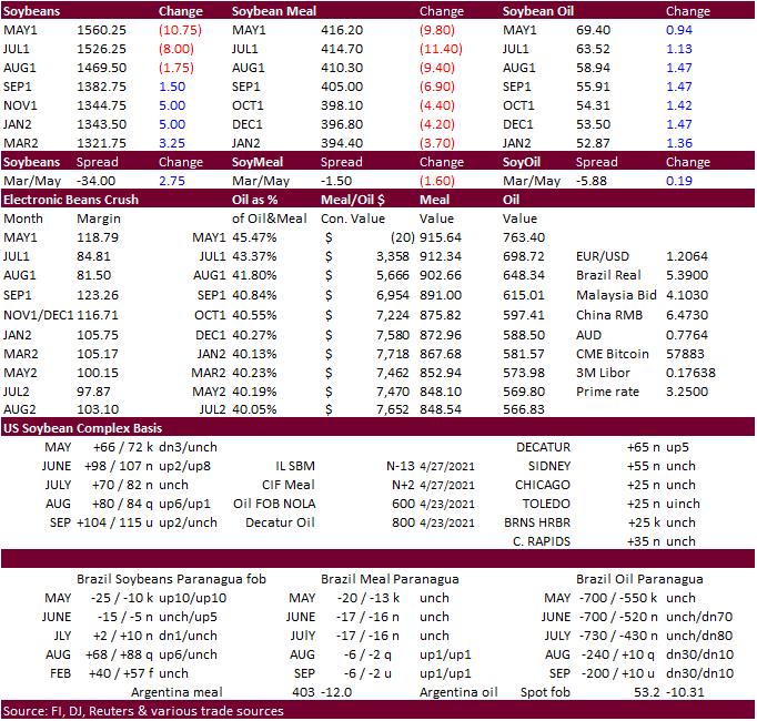
- CBOT
soybeans
traded in a choppy two-sided range with heavy spreading dragging old crop lower while it supported new crop. Meal was on the defensive on soybean oil/meal spreading. Earlier today there was a commercial squeeze in the May soybean oil contract that fueled
a rally to 71.59¢ per lb., which is the highest ever for a front-month contract. May ended lower and back months higher.
- We
heard the US cash market for soybeans was very quiet, especially for exports.
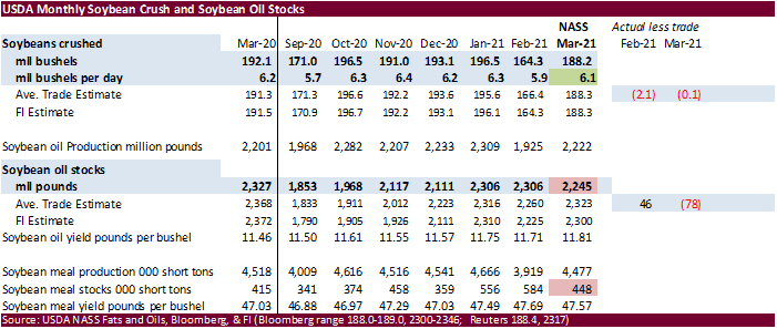
- USDA
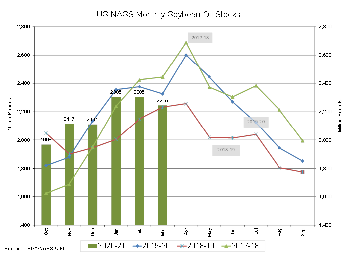
March US soybean crush came in 0.1 million bushels below expectations at 188.2 million, 6.1 million per day, up from 5.9 million per day for February and down from 6.2 million for March 2020. Soybean oil stocks declined to 2.245 billion from 2.306 billion
at the end of February and are below 2.327 billion a year ago. Stocks were 78 million pounds below a Bloomberg trade guess. Soybean meal stocks also fell to 448,000 short tons from 584,000 at the end of February. We find this bullish SBO and meal relative
to soybeans. - China
will be on holiday through Wednesday for Labor Day. - Malaysian
palm oil appreciated a large 193 points to 4061 and cash palm was up $32.50/ton to $1,017.50. EU veg oils and meal were mostly higher.
- Soybean
meal basis was up $2.00 for Cedar Rapids (-10N), Iowa Falls (-15N) and Sioux City, IA (-20N). Eastern Belt was mostly unchanged at 14 to 18 over the July.
- USDA
US soybean export inspections as of April 29, 2021 were 143,418 tons, below a range of trade expectations, below 284,074 tons previous week and compares to 381,177 tons year ago. Major countries included Mexico for 57,978 tons, Costa Rica for 16,697 tons,
and Indonesia for 14,566 tons. - Funds
on Monday sold an estimated net 10,000 soybean contracts, sold 7,000 soybean meal and bought 7,000 soybean oil.
- Cargo
surveyor SGS reported month to date April Malaysian palm exports at 1,413,094 tons, 102,757 tons above the same period a month ago or up 10.1%, and 157,831 tons above the same period a year ago or up 16.5%. AmSpec reported April Malaysian palm exports increased
9.7% to 1.4 million tons.
- Results
awaited: Algeria
seeks 30,000 tons of soybean meal on April 29 for shipment by June 15. - Results
awaited: Tunisia seeks 27,000 tons of soybean oil and/or rapeseed oil for late June / early July shipment.
Updated
4/26/21
July
soybeans are seen in a $14.75-$16.50; November $12.75-$15.00
Soybean
meal – July $400-$460; December $380-$460
Soybean
oil – July 56-70; December 48-60 cent range
- US
wheat traded two-sided Monday, ending lower. It was up earlier from strength in corn and a lower USD (-30 as of 3:30 pm CT). US wheat conditions declined one point, at trade expectations.
- USDA
US all-wheat export inspections as of April 29, 2021 were 509,932 tons, within a range of trade expectations, below 581,087 tons previous week and compares to 588,193 tons year ago. Major countries included China for 165,891 tons, Mexico for 67,379 tons, and
Japan for 59,111 tons. - SovEcon
increased their estimate for the Ukraine 2021 wheat crop to a record 28.6 million tons from the previous estimate of 27.8 million tons and 24.9 million tons harvested in 2020. They also have Ukraine corn production at a record high 36.6 million tons versus
30.3 million tons in 2020. - Egypt
bought at least 1 million tons of local wheat so far this season. - Funds
on Monday sold an estimated net 12,000 CBOT SRW wheat contracts.
- The
Philippines seeks up to 185,000 tons of wheat on May 4 for shipment in June, July and August depending on origin.
- Bangladesh
seeks 50,000 tons of milling wheat on May 6.
Rice/Other
·
Results awaited: Offers low as $407.79/ton – Bangladesh seeks 50,000 tons of rice on May 2.
Updated
4/26/21
July
Chicago wheat is seen in a $6.75-$8.00 range
July
KC wheat is seen in a $6.60-$7.50
July
MN wheat is seen in a $7.15-$8.00
Terry Reilly
Senior Commodity Analyst – Grain and Oilseeds
Futures International
One Lincoln Center
18 W 140 Butterfield Rd.
Oakbrook Terrace, Il. 60181
W: 312.604.1366
ICE IM:
treilly1
Skype: fi.treilly

Trading of futures, options, swaps and other derivatives is risky and is not suitable for all persons. All of these investment products are leveraged, and you can lose more than your initial deposit. Each investment product is offered
only to and from jurisdictions where solicitation and sale are lawful, and in accordance with applicable laws and regulations in such jurisdiction. The information provided here should not be relied upon as a substitute for independent research before making
your investment decisions. Futures International, LLC is merely providing this information for your general information and the information does not take into account any particular individual’s investment objectives, financial situation, or needs. All investors
should obtain advice based on their unique situation before making any investment decision. The contents of this communication and any attachments are for informational purposes only and under no circumstances should they be construed as an offer to buy or
sell, or a solicitation to buy or sell any future, option, swap or other derivative. The sources for the information and any opinions in this communication are believed to be reliable, but Futures International, LLC does not warrant or guarantee the accuracy
of such information or opinions. Futures International, LLC and its principals and employees may take positions different from any positions described in this communication. Past results are not necessarily indicative of future results.