PDF attached includes our updated US acreage table.
Attached
is out updated US acreage table. The US will be on holiday Monday. Inflation fears and a sharply lower USD sent grains and soybeans higher. Soybean meal was up strong. Bearish fundamentals sent soybean oil lower. The USD was 150 points lower as of 1:30 PM
CT. WTI crude oil started lower before reversing to trade higher. USDA export sales were within expectations. Most of the US Midwest will be dry through the end of the week. The two-week outlook calls for around 60-65 percent of normal precipitation for the
US Midwest, and warm temperatures for the remainder of the month.
Crop
Progress
Last
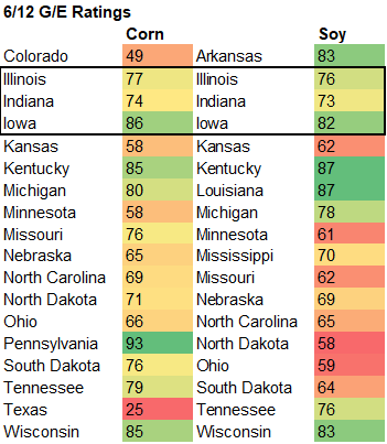
week Iowa posted good corn and soybean crop conditions. This week we look for the US corn and soybean ratings to slip a touch from last week. That report will be updated Tuesday as the US government will be closed for holiday Monday.
WEATHER
EVENTS AND FEATURES TO WATCH
- NWS
30-Day Outlook finally jives much better with the World Weather outlook that has been advertised since February - NWS
predicts July temperatures to be warmer than usual from the central and southern Rocky Mountain region and southwestern desert region through the central and southern Plains to the Atlantic Coast states - The
only cooler biased temperatures were along the Pacific Northwest coast - All
other areas were suggested to have equal chances for above, below and near normal temperatures - NWS
predicts July precipitation to be below normal from southeastern Wyoming, Eastern Colorado, northeastern New Mexico and West Texas to Illinois, western Indiana and the northern Delta - Precipitation
was suggested to be greater than usual from northern Florida to coastal southeastern New England as well as in Arizona and western New Mexico - NWS
90-day outlook suggests below normal precipitation July through September from western Wisconsin, western Illinois, Missouri, Oklahoma and northern and western Texas to eastern Washington State, Montana, North Dakota, Minnesota and Wisconsin - Greater
than usual rainfall was advertised for the Atlantic Coast states south of Maine and in northern Florida and southeastern Alabama as well as in Arizona - Temperatures
during the July through September period were predicted to be warmer than usual in most of the contiguous United States - NOAA
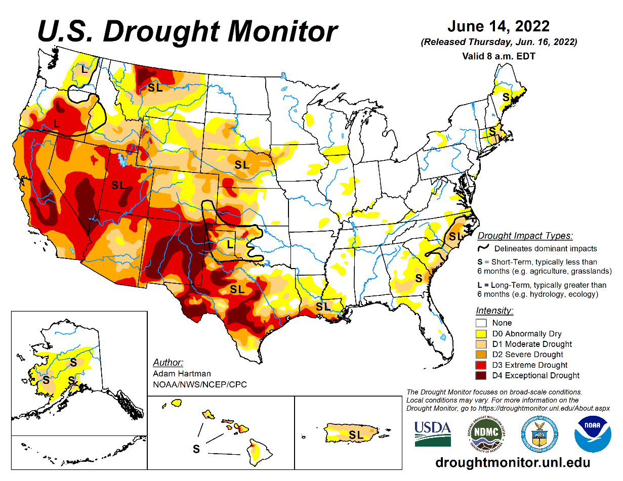
drought forecast for the next three months suggests developing drought in Illinois and the Delta as well as parts of southeastern and northwestern Iowa and northeastern Texas - Drought
in other areas was expected to persist except in Arizona and western New Mexico where monsoonal precipitation was expected to ease - World
Weather, Inc. believes the NWS finally has caught onto the forecast for this summer. Verification in the 30- and 90-day outlook should be much more likely with the changes presented today - World
Weather, Inc. will make no changes to its outlook based on the latest data - U.S.
weather outlook continues to be tenuous – at best with net drying quite likely over the next two weeks in the central and southern Plains, Delta and southwestern Corn Belt - Waves
of rain will occur infrequently across northern and eastern parts of the Midwest with some reaching the lower eastern Midwest infrequently - Much
of the precipitation in the southwest will not counter evaporation very well
- The
northern Plains and Canada’s Prairies should see rain most routinely with the Prairies wettest during the next two weeks - U.S.
monsoonal moisture is getting under way in the southwestern desert region and will feed precipitation up from Mexico into the Rocky Mountains during July, August and early September with the late June rainfall expected to be greatest from Arizona to Colorado
and parts of Utah - U.S.
heatwave is expected this weekend across the Great Plains and into a part of the western Corn Belt as well as clipping the southeastern corner of Canada’s Prairies
- Temperature
extremes will reach over 100 Fahrenheit from the Dakotas and western Minnesota to Texas this weekend, but the northern parts of the heatwave should get relief during the early to middle part of next week
- The
hottest conditions should not reach east of the Mississippi River, although it will warm up there as well after a brief break from warm to hot weather today and Friday - West
Texas has a chance for showers in the middle to latter part of next week, but the heat will prove to be too much and any relief that occurs to the region’s dryness will last only a few hours - Heat
and dryness continue to threaten most of the region’s corn, sorghum and cotton and next week’s showers will offer no change
- Canada’s
Prairies will continue to experience waves of rain over the next two weeks maintaining an improving trend for the drought stricken areas in the southwest and maintaining moisture abundance in the east - Some
abandonment of cropland is necessary in Manitoba and east-central Saskatchewan because of excessive moisture - Ontario
and Quebec rainfall should be favorably distributed over the next two weeks supporting corn, soybean and wheat
- GFS
06z model predicted tropical cyclone in Gulf of Mexico that moves into Texas after June 25 will not likely verify - Scattered
showers in the U.S. southeastern states will help slow the region’s drying trend over the coming week, but a net decline in soil moisture is expected in many areas
- Some
increase in rainfall “may” evolve in the June 23-29 period - U.S.
Delta will experience net drying during the coming week to ten days, despite some isolated to showers and thunderstorms - Temperatures
will be warm enough to keep evaporation rates high - Crop
stress is expected as the region dries out - U.S.
far western states will experience net drying during much of the next ten days, although some rain will fall in the Cascade Mountains and along the Washington and Oregon coast as well as the far northern Rocky Mountains - Livestock
and crop stress is expected through early next week as waves of excessive heat continue to impact the U.S. Plains, Midwest, Delta and southeastern states - Extreme
highs in the central Plains this weekend may reach 110 degrees Fahrenheit - U.S.
Midwest, Delta and southeastern states will see highs in the 90s to near 100 degrees Fahrenheit Sunday through Wednesday - Heat
stress is expected for livestock and crops - The
warm weather will also lead to a further decline in soil moisture - Rain
fell beneficially in northern and eastern Saskatchewan, Manitoba and parts of Alberta this week - Relief
has occurred in some of the drought stricken areas of the Prairies and more rain is expected later in the forecast period after a short term bout of drier and warmer weather in the next few days - Western
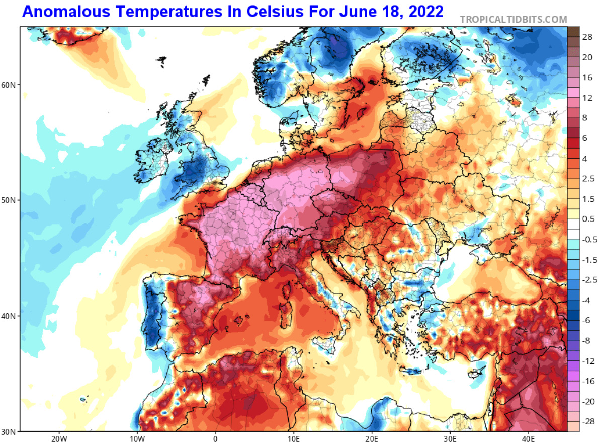
and central Europe will experience net drying conditions through the weekend - Showers
and thunderstorms will slowly increase next week - The
resulting moisture will be extremely important for winter, spring and summer crops after previous days of drying
- Temperatures
will be warm during both weeks of the two-week outlook - Hot
temperatures are expected through the weekend in France, Spain and Portugal with extreme highs reaching into the 90s to 105 degrees Fahrenheit
- Net
drying is expected in many interior parts of Russia’s Southern region, parts of south-central and southeastern Ukraine and western Kazakhstan during the next ten days, although totally dry weather is unlikely - Greater
rain will be needed later in the month of June and July to improve soil and crop conditions - Far
southern Russia and Georgia will experience frequent rain later this week into early next week resulting in a notable boost in soil moisture favoring long term crop development - Western
and northern parts of the Commonwealth of Independent States will experience frequent rainfall over the next ten days maintaining moisture abundance in the soil and good crop development potential - Rain
in northern Kazakhstan will be great for spring wheat and some sunseed crops - South
Korea rice areas continue critically dry and are in need of rain - No
relief will occur in this coming week, but some showers may occur in the June 23-29 period - Far
southern China will continue to receive too much rain for another week resulting in more flooding and more concern over rice, sugarcane and some minor corn, soybean and groundnut production areas
- The
heaviest rain should be about over; however - Drying
is badly needed and some may occur next week - Northeast
China will continue to see rain routinely which may challenge summer crop planting since much of the region is already wet - Drying
will be most needed in Liaoning and Jilin where the ground is already a little too wet - China’s
Xinjiang province continues to experience relatively good weather, although warm conditions are expected early to mid-week this week before some welcome cooling occurs in the second half of this week and into the weekend - China’s
North China Plain will see limited rainfall for the coming week and then may get some scattered showers offering limited relief in the June 23-29 period - India’s
monsoonal rainfall will continue to perform poorly for another few days before some increase in rainfall is expected this weekend into next week
- The
greater rainfall next week and in the following week should slowly bring on improved planting and establishment conditions for many summer crops - Greater
rainfall may still be needed - Southern
Australia will receive waves of rain over the next ten days maintaining a very good outlook for wheat, barley and canola - Western
Argentina will remain mostly dry through next week raising concern over winter crop planting and establishment - A
few showers may occur briefly in the second half of the week, but much more will be needed - Most
of next week’s rain will be greatest in Buenos Aires where improved topsoil moisture is expected - At
least some rain is needed in all wheat areas in the nation, although subsoil moisture is still rated well in the east and more rain is expected there in the second half of next week - Southern
Brazil will see more rain this weekend into next week - Improved
Safrinha corn maturation conditions will result and winter wheat improvements are likely while dry weather is present over the next few days - Mato
Grosso, Goias, Minas Gerais, Tocantins, Maranhao, Piaui and Bahia, Brazil will be mostly dry except for showers near the Atlantic coast - Mexico’s
monsoonal rainfall is expected to start a little sporadically leaving parts of the nation quite dry, but a slow increase in precipitation will eventually take place - Interior
western areas will be wettest over the coming week along with southwestern coastal areas and a few lower eastern coastal areas - A
tropical disturbance may bring heavy rain to the Yucatan Peninsula this weekend before reaching the lower east coast of Mexico early next week - Remnants
of the storm could bring some welcome rain to coffee, citrus and sugarcane areas of southern Mexico next week - Another
tropical cyclone may evolve off the lower western Mexico coast during mid-week this week producing heavy rain in southwestern Mexico - Northeastern
Mexico drought will prevail for the next two weeks and may not be relieved without the help of a tropical cyclone - The
same may be true for southern Texas - Southeast
Asia rainfall will continue abundant in many areas through the next two weeks - Local
flooding will impact parts of the Philippines, Indonesia, Malaysia and western parts of Myanmar - Southern
Thailand and western Cambodia along with some central Vietnam crop areas will be driest, but not too dry for normal crop development - East-central
Africa rainfall will occur sufficiently to improve crop and soil conditions from Uganda and southwestern Kenya northward into western and southern Ethiopia - West-central
Africa rainfall has been and will continue sufficient to support coffee, cocoa, sugarcane, rice and cotton development normally - South
Africa’s restricted rainfall in the east over the coming week will be good for summer crop harvest progress and some late winter crop planting - Rain
in western parts of the nation will be good for wheat, barley and canola emergence and establishment - Central
America rainfall will be abundant during the next ten days with excessive rainfall possible along the Pacific Coast
- A
tropical cyclone may form near the Nicaragua and Costa Rica coast during mid-week this week bringing significant rain to northeastern Nicaragua and eventually to eastern Honduras, Belize and then Yucatan Peninsula later this week - Some
very heavy rain will fall in coastal areas. - Today’s
Southern Oscillation Index was +14.61 and it will move erratically over the coming week - New
Zealand rainfall will diminish to infrequent showers over the coming week; recent rain was welcome and beneficial.
Source:
World Weather INC
Source:
World Weather INC
Bloomberg
Ag Calendar
Thursday,
June 16:
- USDA
weekly net-export sales for corn, soybeans, wheat, cotton, pork and beef, 8:30am - HOLIDAY:
Brazil, South Africa
Friday,
June 17:
- ICE
Futures Europe weekly commitments of traders report - CFTC
commitments of traders weekly report on positions for various U.S. futures and options, 3:30pm - FranceAgriMer
weekly update on crop conditions
Saturday,
June 18:
- China’s
second batch of May trade data, including corn, pork and wheat imports
Source:
Bloomberg and FI
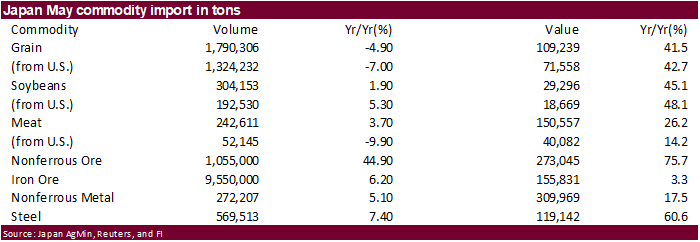
USDA
export sales
were within expectations for most of the major commodities. Soybean commitments are near USDA’s projection, but corn is running well below.

U.S.
GENERATED 1.23 BLN ETHANOL (D6) BLENDING CREDITS IN MAY, VS 1.14 BLN IN APRIL -EPA
U.S.
GENERATED 513 MLN BIODIESEL (D4) BLENDING CREDITS IN MAY, VS 499 MLN IN APRIL -EPA
Year
ago…
U.S.
GENERATED 1.26 BLN ETHANOL (D6) BLENDING CREDITS IN MAY 2021, VS 1.14 BLN IN APRIL -EPA
U.S.
GENERATED 396 MLN BIODIESEL (D4) BLENDING CREDITS IN MAY 2021, VS 386 MLN IN APRIL -EPA
Macros
ARGENTINA
CENTRAL BANK RAISES INTEREST RATE BY 300 BASIS POINTS TO 52% .
US
Housing Starts (M/M) May: -14.4% (est -1.8%; prev -0.2%)
US
Housing Starts May: 1549K (est 1693K; prev 1724K)
US
Building Permits (M/M) May: -7.0% (est -2.5%; prevR -3.0%)
US
Building Permits May: 1695K (est 1778K; prevR 1823K)
US
Initial Jobless Claims Jun 11: 299K (est 217K; prevR 232K)
US
Continuing Claims Jun 4: 1312K (est 1304K; prevR 1309K)
US
Philadelphia Fed Business Outlook Jun: -3.3 (est 5.0; prev 2.6)
Canada
Wholesale Trade Sales (M/M) Apr: -0.5% (est 0.2%; prev 0.3%)
·
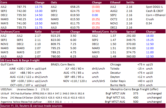
US corn futures traded higher from a drop in the USD, inflation concerns and unfavorable US weather. We are thinking US corn and soybean crop conditions could slip when updated this Tuesday (US on holiday Monday).
·
Chicago corn basis was last 75 over July. On Monday it was +45.
·
Reuters reported China’s sow heard at the end of May was 41.92 million heads, 0.4 percent above April and 4.7 percent below year earlier.
·
On Thursday the US House will vote on the Lower Food and Fuel Cost Act that includes year-round E15 ethanol blending and $200 million in additional funding for higher blends infrastructure.
Export
developments.
·
China seeks to buy 40,000 tons of frozen pork for reserves on June 17.
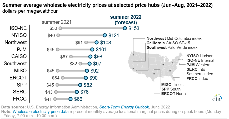
EIA
expects significant increases in wholesale electricity prices this summer
https://www.eia.gov/todayinenergy/detail.php?id=52798&src=email
Brazil
Expecting Historic Safrinha Despite Less Than Ideal Weather
Colussi,
J., G. Schnitkey and C. Zulauf. “Brazil Expecting Historic Safrinha Despite Less Than Ideal Weather.”
farmdoc daily (12):90, Department of Agricultural and Consumer Economics, University of Illinois at Urbana-Champaign, June 15, 2022.
Updated
6/14/22
July
corn is seen in a $7.00 and $8.25 range
December
corn is seen in a wide $5.75-$8.25 range
