PDF Attached
Mixed
trade in US commodity markets and rally in US equities created a slow trade in CBOT agricultural futures, but in large part to lack of direction. News was also light. Some spreading commenced in wheat and corn. Others were looking at a bull situation in soybean
oil after global vegoil markets rallied early Monday. Funds have been buyers of ags in recent days, or at least until today (sold corn, soybeans and meal on Monday).

World
Weather Inc.
WEATHER
EVENTS AND FEATURES TO WATCH
- Weekend
rainfall in South America was varied with southwestern Brazil, Paraguay, Uruguay and eastern Argentina dry - Argentina
rainfall was greatest in the heart of Buenos Aries and from there into southern Cordoba and northeastern Santa Fe where 0.75 to 1.34 inches resulted - Lighter
rain fell in other Cordoba and Santiago del Estero and southern Santa Fe locations with rainfall of 0.05 to 0.75 inch resulting - All
other areas in Argentina were dry - Temperatures
were seasonable - Rain
in Brazil was widespread in the north and southeastern parts of the nation leaving Rio Grande do Sul, western Santa Catarina, western Parana, Paraguay, Mato Grosso do Sul and southern Mato Grosso dry
- Rainfall
from northeastern Rio Grande do Sul through central and eastern Parana to central and western Sao Paulo and southern Minas Gerais varied from 0.05 to 0.75 inch with a few amounts of up to 1.50 inches - Greater
rain fell across central and northern Mato Grosso, eastern Bahia and east-central Minas Gerais where local totals of 1.00 to 2.00 inches and a few amounts more than 2.00 inches were noted.
- Temperatures
in Brazil were also seasonable - Even
though rain will eventually fall in the drier areas of interior southern Brazil the region will be dry today through Friday raising moisture stress in western Parana where the ground is already a bit dry along with a few neighboring areas - These
areas should get rain late this weekend into next week, but if they do not get the moisture, crop stress will rise further and the situation will need to be closely monitored - Brazil
crop areas from Mato Grosso to Bahia and Minas Gerais will get rain routinely over the next two weeks keeping crops in good condition - Crops
in Mato Grosso do Sul to Sao Paulo, Parana and Santa Catarina will get their precipitation late this weekend into next week with relatively dry biased conditions until then
- Flooding
rain is expected briefly this week in Espirito Santo, northeastern Minas Gerais and southeastern Bahia where 2.00 to 6.00 inches and local totals as great as 8.00 inches will fall by Friday morning - Limited
rainfall is still expected from eastern Argentina through southern Brazil and southernmost Paraguay during the coming ten days - Any
rain that falls in these areas will be very brief and light resulting in net drying conditions - The
area including Corrientes, much of Santa Fe, northeastern Buenos Aires, Chaco, eastern Formosa, Uruguay, Rio Grande do Sul and southernmost Paraguay - Pockets
of dryness may evolve and expand during the ten-day period ending Dec. 15, but serious crop stress will likely be slow to evolve due to favorable subsoil moisture and seasonable temperatures - The
need for rain in these areas will steadily rise especially during the weekend and next week after this week’s drying firms up the topsoil - The
urgency for rain will rise near and beyond mid-month if dryness is still persisting - Rio
Grande do Sul will be the first area to begin to experience notable moisture stress
- Tropical
Depression Jawad has had a minimal impact on India’s upper east coast - The
storm dissipated off the upper east coast of India Sunday - Rainfall
varied up to 3.50 inches through dawn today in Odisha and West Bengal, India. Some greater amounts were suspected, though - No
damage to rice, sugarcane or any other crop is expected, despite local flooding - U.S.
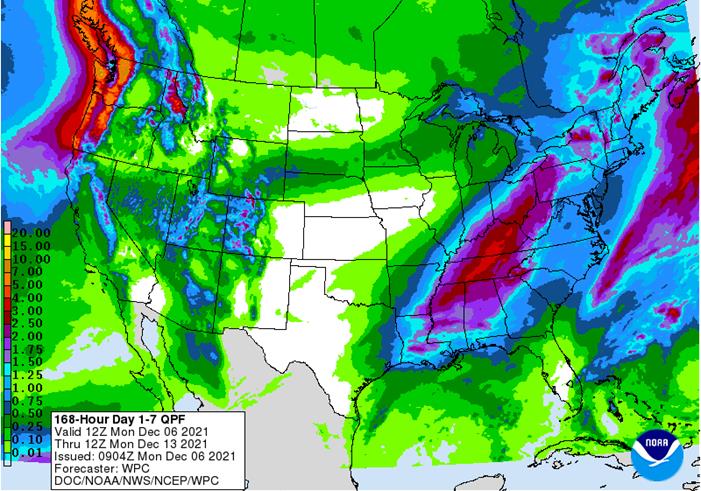
weekend precipitation was mostly confined to the northern states from Washington and northern Oregon through Montana to North Dakota, northern South Dakota and into the western Great Lakes region - Moisture
totals varied up to 0.50 inch except in the mountains of northern Idaho and in the Cascade Mountains where up to 0.84 inch and 1.25 inches occurred respectively.
- Snowfall
through dawn today varied from 2 to 6 inches except along U.S. Highway 2 from near Devils Lake to Lavina, MN in which 6- to 11-inch totals occurred with 12 inches at Tolna, N.D. and 14 inches at Solway, Minnesota - Some
of the snow reached in central and northern Wisconsin where 5-11 inches resulted - Similar
amounts occurred in northern Lower Michigan and most of Upper Michigan - Rain
developed in the eastern Midwest and northern Delta Sunday with moisture totals of 0.20 to 0.70 inch except near and south of the Ohio River where some 0.70 to 2.12-inch amounts resulted. - Kentucky
and north-central Tennessee were wettest with amounts over 1.00 inch - Most
other crop areas were dry in the U.S. were dry - U.S.
Outlook for the coming week….. - Today’s
snow in the northern Midwest will shift through the Great Lakes region to the Ontario and Quebec crop areas and a part of far northern New England the remainder of today
- Another
2-10 inches of accumulation is expected in southern Quebec, Ontario and both northern New York and northern New England
- Rain
will fall from the lower U.S. Delta region through the Tennessee River Basin to southern New England today with moisture totals of 0.50 to 1.50 inches and a few amounts over 2.00 inches - Lingering
showers will occur in the eastern U.S. Tuesday and then one more disturbance is expected in the Midwest, interior northern Plains and Delta Thursday into the weekend with moisture totals of 0.10 to 0.75 inch in the Midwest and local totals of 1.00 to 1.50
inches in the lower eastern Midwest, Delta and Tennessee River Basin - Snow
will fall from South Dakota to the western Great Lakes region Thursday and Friday with 3 to 9 inches of accumulation possible and moisture totals to 0.75 inch.
- Some
locally greater amounts are expected as well - Another
rain event is expected in the Delta, Tennessee River Basin and interior southeastern states to southern New England this weekend with rainfall of 0.50 to 2.00 inches - U.S.
temperatures will be near to above normal during most of this coming week, although today and Tuesday will be quite cold in the north-central states - U.S.
week two weather, Dec. 13-19 will be limited in the Great Plains and southwestern states as well as a part of the southeastern states while rain falls lightly in the northern and eastern Midwest and from California into the Great Basin - U.S.
hard red winter wheat production areas will receive a minimal amount of moisture during the next two weeks and temperatures will be warmer than usual - Net
drying is expected and crops will remain dormant or semi-dormant in the majority of areas, despite the warmer than usual bias - Restricted
precipitation will continue in the northwestern U.S. Plains over the next two weeks, although totally dry weather is unlikely - U.S.
southeastern states will also experience net drying conditions, especially in areas near the coast in South Carolina, Georgia and across much of Florida - U.S.
Delta weather will be wettest in this first week of the outlook with less precipitation in the second week of the outlook - California
may experience a boost in precipitation throughout the state for a little while next week
- The
moisture will increase mountain snow pack and short term soil moisture - Mexico
precipitation will be limited to the east coast over the next ten days with areas from Tamaulipas to Veracruz and Chiapas most impacted - Resulting
rainfall will rarely bolster soil moisture for very long - Net
drying is expected in most other areas - Central
America precipitation will be greatest along the Caribbean Coast , but including a fair amount of Panama and Costa Rica - Eastern
Australia harvest weather will be better in the next two weeks than in the past several weeks - Rain
will fall infrequently with early to mid-week this week wettest in Queensland and a few New South Wales crop areas most impacted - Friday
of this week through the middle part of next week will be drier biased providing another good opportunity for winter crop harvest progress and summer crop planting and early season spraying fertilizing - Southern
Australia will be dry during much of the next ten days supporting good to excellent winter crop maturation and harvest weather - Australia
weekend precipitation was mostly confined to a few locations in Victoria and mostly the Pacific Coast from southeastern Queensland to northeastern New South Wales
- Rainfall
will vary up to 0.30 inch with a few totals in northeastern New South Wales in Dairy and sugarcane areas getting 1.00 to 2.00 inches
- Temperatures
were quite warm to hot in north-central and northwestern parts of the nation outside of key crop areas where highs in the 90s to 108 Fahrenheit was common
- Mostly
from central and western Queensland to northern parts of Western Australia - South
Africa received frequent showers and thunderstorms during the weekend with nearly 85% of the nation getting rain at one time or another - Moisture
totals varied widely with some 1.00- to 2.00-inch totals occurring erratically across the nation while other areas received less than 0.60 inch resulting in net drying conditions - A
more uniform distribution of rain is needed - South
Africa’s rainfall distribution will continue erratic over the next two weeks, but all areas will be impacted at one time or another and the environment will be supportive of summer crop development - Temperatures
will be close to normal - The
bottom line for South Africa should be good for long term crop development - Europe
precipitation was bolstered higher during the weekend, although none of it was a surprise - France
was wettest along with a few areas from Italy into Bulgaria and Serbia where 0.35 to 1.00 inch totals were common with a few amounts of 1.00 to 200 inches - Spain,
Portugal and far eastern Europe were driest - Temperatures
were mild to cool keeping winter crops dormant or semi-dormant except in the far south and west-central parts of the region where a little more growth may have occurred briefly - Europe
will receive periods of rain and mountain snowfall during the next ten days to two weeks.
- Most
areas will be impacted at one time or another and the moisture will be of great use in the spring - Precipitation
is needed most in parts of Romania, Spain and Portugal where the soil is still running short to very short of moisture - Temperatures
will be slightly cooler-biased - Russia,
Ukraine, Baltic States and Belarus are unlikely to see threatening cold in the next ten days and waves of snow and rain are expected - CIS
soil moisture will slowly improve in this weather pattern - Not
many areas need moisture, but dryness remains in northern Kazakhstan and southernmost parts of Russia’s New Lands - Some
southward expansion of cold air in the CIS New Lands is advertised for next week, but the cold will stay out of winter wheat production areas - Latest
La Nina data shows a more gradual weakening trend after the late December early January peak in the event. - Previous
NOAA model runs had La Nina weakening aggressively - Now
La Nina still has some influence into April – if their forecast is correct - World
Weather, Inc. believes there is potential for this La Nina event to linger longer and it would not be surprising to see it last through the spring
- That
is just speculation for now, but similar conditions have occurred in other 22-year solar cycles - The
implication of a longer lasting La Nina in the spring would be greater concern for ongoing dryness in the Plains and a part of the western Corn Belt - Still
just speculation for now - Did
you know the Joint Institute for the Study of the Atmosphere and Ocean (JISAO)’s original Pacific Decadal Oscillation Index (PDO) fell to its lowest level since 1956 in October of this year - Some
believe strongly negative PDO events that last over multiple months lead to droughts especially when they occur in the summer
- Keep
an eye on this event for 2022 U.S. agricultural weather especially if La Nina stays longer - Strongly-positive-phased
Arctic Oscillation (AO) present in the Northern Hemisphere today is ensuring that no mid-latitude winter agricultural region in the Northern Hemisphere will be subjected to threatening cold for the next ten days and probably not for two weeks - This
is true for the United States, Europe and all of Asia - Some
“cooler” air will be around in a few areas, but no crop threatening cold is anticipated - Canada
and the far northern U.S. Plains will see two days of bitter cold Sunday and Monday, but it will be quick to abate without going any farther to the south - India
rainfall during the weekend was limited - Odisha
and West Bengal were wettest with 0.50 to 2.00 inches resulting mostly because of Tropical Cyclone Jawad - Rain
also fell from western Maharashtra to Tamil Nadu where 0.30 to 1.77 inches resulted - Most
other areas were dry - India
rainfall in the far south will slowly diminish bringing a period of welcome dry conditions that will support much improved summer crop maturation and harvest conditions and better winter crop harvest conditions - Many
areas will be dry during the weekend and on into early next week - Waves
of rain are expected in southwestern British Columbia and western most Washington State including some of the more important ports from the Puget Sound into Vancouver and neighboring areas of British Columbia - Delays
in the loading and shipping of some goods and services may result due to flooding, but the worst of the stormy pattern may be passing - Frequent
rain could still induce some delays - Friday
through the weekend coming up will be the next stormy period - China’s
weather during the next ten days will continue relatively quiet with only brief periods of light precipitation expected - The
precipitation is expected to be most significant in the northeastern and east-central provinces where snow and rain will fall respectively - Northern
wheat production areas were trending dormant or semi-dormant and winter crops should be adequately established - Rapeseed
planting should be winding down in the Yangtze River Basin - Soil
moisture is favorably rated for good rapeseed establishment - Middle
East weather is a little dry from Syria, Iraq and Jordan to Iran while portions of Turkey have favorable soil moisture.
- Eastern
parts of the Middle East may experience additional drying for a while - Northern
Iraq and Iran are advertised to be wetter in the Dec. 13-19 period, although confidence is a little low - Western
Turkey will be wettest - North
Africa rainfall is expected to occur periodically during the next ten days, but Morocco (especially the southwest) will be missed by significant rain - Coastal
areas of central and eastern Algeria will be wettest - West-central
Africa rainfall during the next ten days will be greatest in coastal areas leaving most interior coffee, cocoa, sugarcane, rice and cotton production areas in a favorable maturation and harvest environment
- Sierra
Leone and Liberia will be wetter than any other country to the east into Cameroon and Nigeria - Colombia
and Venezuela precipitation is expected to occur often in coffee and sugarcane production areas during the next ten days, but no excessive rain is expected - Much
of southeastern Asia will see alternating periods of rain and sunshine - This
will impact the Philippines, Indonesia and Malaysia most often with some net drying expected in interior parts of mainland Southeast Asia - Today’s
Southern Oscillational Index was +13.1 and it was expected to move a little higher this week
- New
Zealand rainfall is expected to be near to above average this week with temperatures warmer than usual in the north and cooler than usual in the central and south - Temperatures
will be seasonable
Tuesday,
Dec. 7:
- China’s
first batch of November trade data, including soybean, edible oil and meat imports - Abares’
quarterly agricultural commodities report - French
agriculture ministry’s monthly crop production estimate - New
Zealand global dairy trade auction - EU
weekly grain, oilseed import and export data
Wednesday,
Dec. 8:
- EIA
weekly U.S. ethanol inventories, production - Fitch
ESG Outlook Conference Asia Pacific, day 1 - FranceAgriMer’s
monthly grains report
Thursday,
Dec. 9:
- USDA’s
monthly World Agricultural Supply and Demand (WASDE) report, noon - USDA
weekly net-export sales for corn, soybeans, wheat, cotton, pork and beef, 8:30am - China
farm ministry’s monthly crop supply-demand report (CASDE) - Brazil’s
Conab report on yield, area and output of corn and soybeans - Fitch
ESG Outlook Conference Asia Pacific, day 2 - Port
of Rouen data on French grain exports
Friday,
Dec. 10:
- ICE
Futures Europe weekly commitments of traders report (6:30pm London) - CFTC
commitments of traders weekly report on positions for various U.S. futures and options, 3:30pm - Malaysian
Palm Oil Board’s data on November palm oil reserves, output and exports - Malaysia’s
Dec. 1-10 palm oil exports - HOLIDAY:
Thailand

FI
estimates below
USDA
inspections versus Reuters trade range
Wheat
245,963 versus 150000-400000 range
Corn
758,169 versus 600000-1000000 range
Soybeans
2,246,664 versus 1850000-2325000 range

GRAINS
INSPECTED AND/OR WEIGHED FOR EXPORT
REPORTED IN WEEK ENDING DEC 02, 2021
— METRIC TONS —
—————————————————————————-
CURRENT PREVIOUS
———–
WEEK ENDING ———- MARKET YEAR MARKET YEAR
GRAIN 12/02/2021 11/25/2021 12/03/2020 TO DATE TO DATE
BARLEY
73 98 1,397 10,010 17,751
CORN
758,169 805,214 824,506 9,378,792 11,168,642
FLAXSEED
0 0 24 124 437
MIXED
0 0 0 0 0
OATS
0 0 0 300 1,595
RYE
0 0 0 0 0
SORGHUM
169,626 190,649 73,503 1,113,964 1,528,975
SOYBEANS
2,246,664 2,258,305 2,595,351 23,569,566 29,867,072
SUNFLOWER
0 0 0 432 0
WHEAT
245,963 390,771 537,077 11,147,986 13,476,544
Total
3,420,495 3,645,037 4,031,858 45,221,174 56,061,016
—————————————————————————-
CROP
MARKETING YEARS BEGIN JUNE 1 FOR WHEAT, RYE, OATS, BARLEY AND
FLAXSEED;
SEPTEMBER 1 FOR CORN, SORGHUM, SOYBEANS AND SUNFLOWER SEEDS.
INCLUDES
WATERWAY SHIPMENTS TO CANADA.
Macros
74
Counterparties Take $1.488 Tln At Fed Reverse Repo Op. (prev $1.475 Tln, 73 Bids)
(Reuters)
– Oil prices rose by more than $3.40 a barrel on Monday after top exporter Saudi Arabia raised prices for its crude sold to Asia and the United States, and as indirect U.S.-Iran talks on reviving a nuclear deal appeared to hit an impasse.
·
CBOT corn fell in the front three months and was higher in the back months on spreading. The lower front month trade was in part to weakness in soybeans and wheat futures plus slow USDA export inspections.
·
Funds sold an estimated net 4,000 CBOT corn contracts.
·
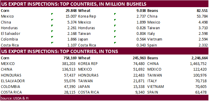
USDA US corn export inspections as of December 02, 2021 were 758,169 tons, within a range of trade expectations, below 805,214 tons previous week and compares to 824,506 tons year ago. Major countries included Mexico for 381,203
tons, China for 136,513 tons, and Honduras for 57,437 tons.
·
Keep an eye on southern Brazil where it has been dry and will remain dry during at least the first half of this week.
Argentina is also expected to dry over the next couple of weeks, but we are hearing crops are in good
shape and could withstand the net drying.
·
China’s statistics bureau pegged corn output up 4.6% in 2021 to 272.6 million tons. China’s 2021 corn planting acreage was up 5% from the previous year at 650 million mu (43.32 million hectares).
Export
developments.
·
None reported
Prospects
for Swine Feed Costs in 2022
Langemeier,
M. “Prospects for Swine Feed Costs in 2022.” farmdoc daily (11):161, Department of Agricultural and Consumer Economics, University of Illinois at Urbana-Champaign, December 3, 2021.

Updated
11/23/21
March
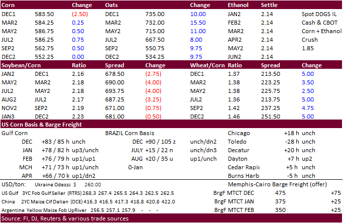
corn is seen in a $5.25-$6.25 range
·
Soybeans
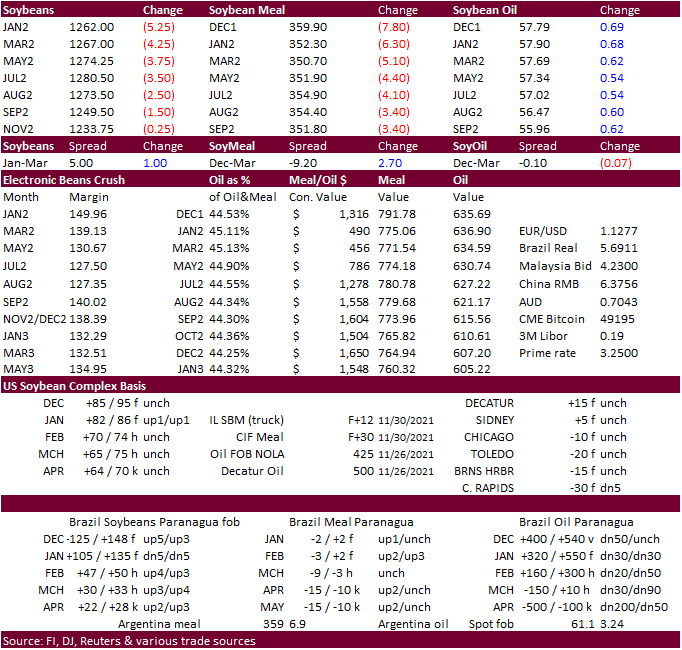
and meal ended lower while SBO settled higher in part to higher Malaysian palm overnight and strength in China vegetable oils. There has been some disappointment over China buying of SA soybeans when it’s a time US dominates market share. The trade is expecting
an announcement from the EPA soon over biofuel mandates. As we mentioned Friday, some traders might be looking for a bullish announcement.
·
Brazil was 94% planted for soybeans as of late last week, meaning FH January shipments are likely with early plantings this year.
·
USDA US soybean export inspections as of December 02, 2021 were 2,246,664 tons, within a range of trade expectations, below 2,258,305 tons previous week and compares to 2,595,351 tons year ago. Major countries included China for
1,463,752 tons, Mexico for 122,420 tons, and Taiwan for 100,976 tons.
·
Soybean meal basis across selected US locations fell $2-$7/short ton. Meal demand should remain robust with high corn prices.
·
Funds sold an estimated net 6,000 soybean contracts, sold 7,000 soybean meal and bought 3,000 soybean oil.
·
Last week it was thought China bought 25-30 cargoes of soybeans.
·
US/China political tensions increased over the weekend after the US threatened to boycott the Olympics. This was talked about before and we don’t read too much into this but something to keep an eye on.
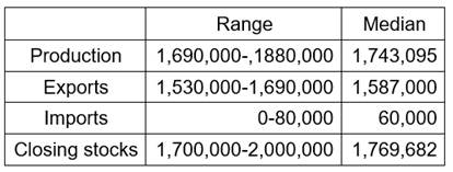
November
MPOB estimates via Reuters
Export
Developments
·
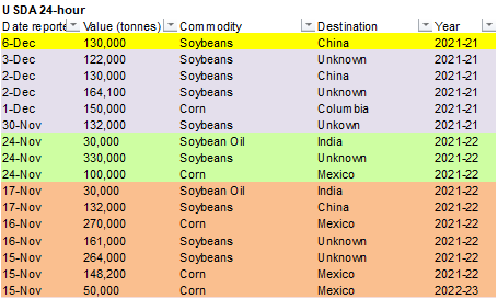
Private exporters reported the following:
-130,000
metric tons of soybeans to China during the 2021/2022 marketing year
Updated
11/30/21
Soybeans
– January $11.75-$13.00 range, March $11.75-$13.50
Soybean
meal – January $320-$370, March $315-$380
Soybean
oil – January 54.00-59.00, March 54.00-62.00
·
After a two-sided trade, US wheat settled mostly higher (Chicago and MA higher, KC nearby on the defensive) on spreading and good export demand out of the Black Sea region, leaving many to worry US exports are waning. Although
some traders noted a declined in Russian fob wheat export prices that sent giggers to the Paris market. But Mastiff rebounded to close higher. March Matif Paris wheat settled 2.00 euros higher at 291.75.
·
Reuters: “Russian wheat with 12.5% protein loading from Black Sea ports for supply in December was quoted at $337 a ton free on board (FOB) at the end of last week, down $3 from the previous week” – IKAR”
·
USDA US all-wheat export inspections as of December 02, 2021 were 245,963 tons, within a range of trade expectations, below 390,771 tons previous week and compares to 537,077 tons year ago. Major countries included Korea Rep for
74,480 tons, Mexico for 51,692 tons, and Honduras for 22,483 tons.
·
A gradual improvement to the eastern Australian weather outlook over the next 10 days limited gains.
·
Funds bought an estimated net 2,000 Chicago soft red winter wheat contracts.
·
China’s statistics bureau pegged wheat production at 136.9 million tons.
·
Russia may impose a grain export quota for the February 15- June 30 period
at
14 million tons, including 9 million tons of wheat.
Export
Developments.
·
Saudi Arabia bought 689,000 tons of wheat at an average $365.14/ton
for
arrival between May and July 2022.
That amount was more than expected.
·
Jordan seeks another 120,000 tons of wheat on Dec 9 and seeks 120,000 tons of barley on Dec 8.
·
Bangladesh seeks 50,000 tons of milling wheat on Dec. 8.
Rice/Other
·
South Korea seeks 22,000 tons of rice from the US on December 9 for arrival in South Korea from May 2022 and from August 2022.
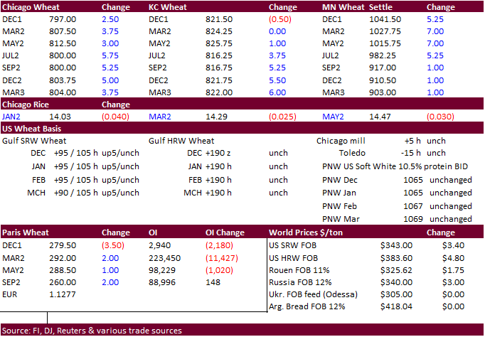
Updated
11/26/21
Chicago
March $7.50-$8.75
KC
March $7.75-$9.25
MN
March $9.50-$11.50
Terry Reilly
Senior Commodity Analyst – Grain and Oilseeds
Futures International
One Lincoln Center
18 W 140 Butterfield Rd.
Oakbrook Terrace, Il. 60181
W: 312.604.1366
ICE IM:
treilly1
Skype: fi.treilly

Trading of futures, options, swaps and other derivatives is risky and is not suitable for all persons. All of these investment products are leveraged, and you can lose more than your initial deposit. Each investment product is offered
only to and from jurisdictions where solicitation and sale are lawful, and in accordance with applicable laws and regulations in such jurisdiction. The information provided here should not be relied upon as a substitute for independent research before making
your investment decisions. Futures International, LLC is merely providing this information for your general information and the information does not take into account any particular individual’s investment objectives, financial situation, or needs. All investors
should obtain advice based on their unique situation before making any investment decision. The contents of this communication and any attachments are for informational purposes only and under no circumstances should they be construed as an offer to buy or
sell, or a solicitation to buy or sell any future, option, swap or other derivative. The sources for the information and any opinions in this communication are believed to be reliable, but Futures International, LLC does not warrant or guarantee the accuracy
of such information or opinions. Futures International, LLC and its principals and employees may take positions different from any positions described in this communication. Past results are not necessarily indicative of future results.
