PDF Attached
Today
was last trade for December futures. Dec corn went off at $4.1925, down 5 cents, Dec meal down $3.30 to $380.80, Dec SBO up 53 to 40.11, and Dec Chicago wheat at $5.9350, down 14.75 cents.
NOT
MANY CHANGES OVERNIGHT
- Argentina
weather did not provide many surprises during the weekend - Rain
was greatest in the northeast from northeastern Santa Fe into Corrientes and northern Entre Rios where 0.40 to 2.25 inches resulted except in northeastern Santa Fe where Reconquista reported 5.59 inches
- Rain
in northern Buenos Aires, the remainder of Entre Rios, the remainder of Santa Fe and southeastern Cordoba reported 0.10 inch 0.50 inch of moisture - Net
drying occurred in most other areas, although up to 0.45 inch of moisture occurred along the south coast of Buenos Aires and in random locations from eastern San Luis to northwestern Cordoba - Highest
afternoon temperatures Friday and Saturday were in the 80s and lower 90s except in northern Argentina where readings were in the 90s to 104 degrees Fahrenheit - Lowest
morning temperatures were in the upper 40s and 50s south and in the upper 50s and 60s north with a few 70s in the extreme north - Argentina
rainfall expected through the weekend will be very important - Amounts
are expected to range from 0.40 to 1.50 inches with locally more - Enough
rain will fall to provide some timely rainfall to key grain and oilseed production areas helping to relieve crop moisture stress and to “temporarily” improve topsoil moisture - Rainfall
will be erratic benefiting all areas for a little while, but some of the lighter rainfall may not carry crops for long without follow up moisture. - Locally
heavy rainfall of 1.50 to 3.00 inches might occur in a very small part of southern Argentina, but it will be rare - Temperatures
are advertised to be close to normal during the next ten days - The
bottom line for Argentina crops would be favorable if rain falls later this week as advertised, but it would not be surprising to see some of the precipitation lighter than advertised. Sufficient rain will fall in northern Argentina to maintain a very good
environment for crop development after some welcome rain fell during this past weekend. The absence of excessive heat will help crops cope with the drier days, but temperatures will still be warm enough to keep evaporation rates high.
- Brazil
rainfall Friday through Sunday was greatest from Mato Grosso into Goias and from western through southern Minas Gerais to northeastern Sao Paulo - Coffee
areas received some of the greatest rainfall in Sul de Minas where 0.70 to nearly 3.00 inches resulted and good coverage - Rain
fell more significantly overnight in central and southern Mato Grosso and western and northern Parana where 0.25 to 1.10 inches resulted with local totals of 1.10 to 2.12 inches; one location in southwestern Mato Grosso do Sul ended up with 3.34 inches of
rain for the weekend. - Other
grain and oilseed areas in the region did not receive quite as much rain with 0.05 to 0.68 inch occurring with a few locally greater amounts - Rain
also fell during the weekend in Rio Grande do Sul where rainfall of 0.30 to 0.91 inch resulted with local amounts to 2.00 inches - Net
drying occurred in Tocantins, Piaui, Bahia, Espirito Santo, northeastern Minas Gerais, Mato Grosso do Sul, Bolivia, Paraguay western Parana, Santa Catarina and northern Rio de Janeiro - Temperatures
were seasonable except from Rio Grande do Sul to Paraguay where readings rose solidly into the 90s and breached 100 degrees in a few locations - Brazil
rainfall will be widespread this week from Paraguay and Rio Grande do Sul to Mato Grosso do Sul, Sao Paulo and southern Minas Gerais; including Parana - Rainfall
for the week will range from 1.00 to 3.00 inches and local totals of 3.00 to 5.00 inches – southeastern Paraguay will be wettest
- Net
drying is expected in other areas of Brazil until late this week and during the weekend when scattered showers and thunderstorms begin to increase - Some
showers will evolve, but resulting rainfall may not be enough to greatly improve soil moisture especially not in the northeast where net drying is expected - Next
week’s rainfall will be greatest in center west through center south Brazil while parts of the far south slowly dry out - Temperatures
will be near to above average this week and a little more seasonable next week - The
bottom line is still favorable for much of Brazil since rain will fall at one time or another in all of the nation over the next two weeks. This first week may be a little dry from northern Mato Grosso do Sul and southern Mato Grosso to Bahia and parts of
Piaui while next week will be driest in the far south and extreme northeast parts of the nation - U.S.
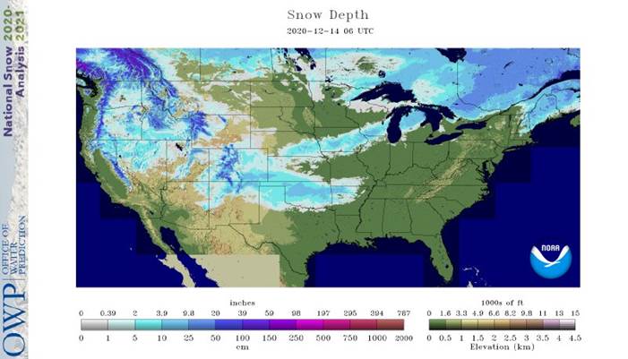
weekend snowfall - Accumulations
ranged from 1 to 3 inches and local totals to 5.00 inches from southeastern Colorado to south-central Kansas, the Texas Panhandle and portions of western and central Oklahoma - Local
totals reached up to 7 inches in the Tulsa, Okla. area - Snowfall
of 1 to 3 inches and local totals to 5 inches also occurred from northeastern Colorado and northwestern Kansas to central Nebraska - Snow
accumulations of 4 to 9 inches also occurred west of Omaha, Neb., from the Des Moines area of Iowa north into the Ames, IA are and from Dubuque, IA into southern and east-central Wisconsin - Snowfall
of 3 to 10 inches and local totals to 15 inches occurred in northern Lower Michigan - U.S.
weekend precipitation totals varied widely from northing in the northern and far southern Plains to amounts of 0.30 to 1.00 inch across the heart of the Midwest and local totals to 1.80 inches in southwestern lower Michigan - Moisture
totals in the Delta varied from 0.25 to 0.75 inch in the north and 1.00 to 2.80 inches elsewhere - Not
much precipitation fell in the southeastern states through Sunday morning, but rain late Sunday and early today varied from 0.25 to 0.75 inch and local totals over 1.00 inch from Virginia into North Carolina and northern Georgia
- Net
drying occurred from southern Alabama and northern Florida into the eastern Carolinas - Much
of the northern Plains was dry except central through southeastern Montana where up to 0.25 inch resulted - Waves
of rain and mountain snow impacted the Pacific Northwest and northern California as well as the northern and central Rocky Mountains - Mostly
dry weather occurred from the southwestern desert region into the southwestern Plains - Temperatures
cooled in the central states during the weekend - Highest
readings Friday and Saturday were in the 20s and 30s in the northern Plains, 30s and 40s in the central Plains and northwestern Midwest while in the 50s, 60s and some 70s from the lower eastern Midwest to the Gulf of Mexico coast - Sunday
afternoon temperatures were limited to the teens and 20s in the northern Plains where lows this morning were -12 to zero in North Dakota and northern Minnesota - Lowest
morning temperatures elsewhere were in the single digits and teens in the remainder of the northern and west-central Plains and in upper single digits and teens in the Texas Panhandle - No
winterkill was suspected due to adequate snow cover in most areas that were coldest - U.S.
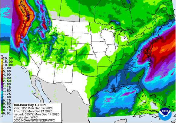
weather this week - Rain
will end in the southeastern and middle Atlantic Coast states today after another 0.20 to 0.75 inch results with local totals over 1.00 inch - Another
small weather system will push through the Plains late today and Tuesday producing a dusting to 3 inches of snow and local amounts to 5 inches or more; Nebraska will be most favored with 1 to 3 inches and local totals over 5 inches - Oklahoma
will receive some rain and snow as well - Rain
and a little wet snow will move through the lower Midwest, Delta and middle Atlantic Ocean Coast Tuesday to Thursday
- Moisture
totals will vary from 0.05 to 0.40 inch with some middle Atlantic coastal areas getting 1.00 to 2.00 inches - A
frontal system will move across the Plains and Midwest late this week and during the weekend producing 0.05 to 0.65 inch of moisture
- Some
of this rain will also impact the Delta and southeastern states - A
frequent succession of storms will move into the Pacific Northwest and pass into the Northern Rocky Mountains before dissipating - A
couple of these storms will move across the northern Plains and into the Midwest early next week with 0.10 to 0.60 inch of moisture resulting - Multiple
inches of snow may accumulate in parts of the Midwest. - U.S.
temperatures will be warmer than usual in the northern Plains and north-central states this week and a little cooler in the second half of next week - Temperatures
will be cold in the northern Plains and upper Midwest today, however - U.S.
hard red winter wheat production areas that received a little moisture during the weekend will receive a little more early this week - The
region will remain drought stricken, but some moisture will help improve surface moisture for a little while.
- Winter
crop conditions still rated poor to good, but with little warming until spring the crop moisture demand will be kept low - U.S.
northern Plains moisture is expected to continue limited over the next ten days - U.S.
southwestern Plains will fail to get much “meaningful” moisture this week, although the light snow that fell during the weekend in the Texas Panhandle and Oklahoma was welcome and should induce a small boost in topsoil moisture when it melts - A
little more precipitation will reach a part of the southern Plains early this week, but moisture totals will still be less than usual - Waves
of precipitation passing through the Pacific Northwest over the next two weeks will improve soil moisture and mountain snowpack for crop use in the spring - Southwestern
U.S. crop areas will remain drier biased over the next two weeks - U.S.
Delta and southeastern states will remain plenty moist over the next two weeks - Eastern
Australia’s weekend precipitation induced some local flooding along the upper New South Wales and lower Queensland coasts
- Some
damage to sugarcane may have occurred, but other crops were not seriously impacted - Australia’s
rain in the coming ten days will advance a little farther inland, but western cotton and sorghum areas are not likely to get much precipitation - Greater
rain is needed in cotton and sorghum areas to improve soil moisture for more significant summer crop development, planting and replanting - India’s
weekend rain was greatest in the far north and a few central areas - Moisture
totals reached 1.00 inch near the Maharashtra/Madhya Pradesh border while most other precipitation in central India was light having a low impact on winter crops - Rain
in northern India was greatest from Jammu and Kashmir through Himachal Pradesh to Uttaranchal and Punjab where some benefit occurred to winter grains - India
will receive a few lingering showers of rain this week - Moisture
totals will be less than 0.40 inch for the week - Any
moisture will be welcome and of some benefit to winter crops - South
Africa weekend rain was greatest from North West through central and eastern Free State to Natal and Eastern Cape - Moisture
totals varied from 0.15 to 1.00 inch with a few 1.00 to 2.00-inch amounts in Nata and Eastern Cape - Planting
and establishment should advance favorably during periods of drier weather - South
Africa will experience additional bouts of rain during the next two weeks further improving soil moisture and supporting crops - Greater
rain is needed in Northern Cape and western Free State - Eastern
China weather during the weekend was mostly dry and mild to cool - Precipitation
during the next two weeks will be brief, but periodic in the Yangtze River Basin keeping dormant winter crops plenty wet - Northern
China winter crops will not experience much precipitation for a while and crops will remain dormant - Southern
Vietnam and Cambodia will trend wetter than usual early to mid-week this week with some of that moisture reaching far southern Thailand as well
- The
moisture will delay harvest progress for some crops, but no serious crop quality changes are likely - Winter
crops will benefit from the expected moisture - Routinely
occurring precipitation is expected in Philippines, Indonesia and Malaysia over the next two weeks - A
tropical disturbance will move through southern Philippines late next week producing some significant rainfall and possible flooding - Greater
rain is needed in parts of Indonesia and Malaysia - A
tropical cyclone may form west of the Philippines late this week or during the weekend before moving toward the southern Vietnam coast next week - Heavy
rain and flooding will be possible, although the storm may diminish while approaching the south coast next week - Some
heavy rain is still expected, though - Russia’s
Southern Region had eastern Ukraine will receive some needed rain and snow later this week - Moisture
totals are unlikely to be great enough to seriously change soil moisture and crops are dormant and unlikely to respond - Moisture
totals will vary up to 0.20 inch - Some
follow up precipitation is “possible” next week and again later this month, but resulting precipitation in each event will be limited - The
bottom line remains one of concern, but World Weather, Inc. believes there will be some increase in soil moisture from periodic precipitation this winter and spring to give crops a chance to improve during the spring. Some increase in snow cover in northern
parts of the production region will help protect crops against any harsh winter weather that comes along - Temperatures
will be a little warmer than usual over the next two weeks - Greece,
Bulgaria, eastern and southern Romania, Moldova and western Ukraine received some needed moisture late last week and during the weekend to bolster soil moisture for crop use in the spring.
- Additional
moisture totals of 0.20 to 1.00 inch resulted during the weekend after similar amounts occurred late last week - Rain
and mountain snow also occurred in France, Spain, Portugal, the United Kingdom and a few other areas in western Europe during the weekend maintaining favorable crop and field conditions - Europe
precipitation during the coming week will be greatest in France, the U.K., northwestern parts of Spain, Portugal and a few other areas in the North Sea region, northern Italy and Greece - Some
local flooding is possible in many of these areas - Net
drying is expected in the Baltic Plain and areas south into the lower Danube River Basin this week, but some of these areas will get moisture next week - Temperatures
will be warmer than usual - North
Africa rainfall during the weekend was greatest in northeastern Algeria where a few 1.00 to 2.00-inch totals resulted - Much
less rain occur occurred in other areas - Morocco
remained driest out of the northern Africa crop areas and continues trying to recover from last year’s drought - Greater
rain may continue to elude the region for the next couple of weeks, despite a few light showers - Southern
Oscillation Index was at +10.76 today and it will remain strongly positive for a while - Tropical
Cyclone Zazu and Tropical Cyclone Yasa in the southwestern Pacific Ocean will not impact any major agricultural area, but the storm system will move through some of the smaller Pacific Islands this week - Mexico
precipitation will be quite limited over the coming week - Portions
of Central America will continue to receive periodic rainfall over the next couple of weeks, but the intensity and frequency will be low enough to support some farming activity - Costa
Rica and Caribbean coastal areas of both Nicaragua and Honduras will be wettest this workweek
- West-central
Africa will experience unusually great rainfall this week stalling harvest progress and raising a little worry over cocoa and coffee conditions - Some
rain will also reach into southwestern Ghana and Senegal - Drier
weather is needed; this is normally the start of the dry season - East-central
Africa rain will be erratic and light in Ethiopia, Kenya and Uganda while rainfall will be greatest over Tanzania this week - Some
rain will develop this weekend into next week in Ethiopia, Kenya and it may increase in Uganda - New
Zealand will be drier than usual this week from northern and central parts of South Island to North Island while rain falls to the southwest - Temperatures
will be near to above average
Source:
World Weather Inc. and FI
Tuesday,
Dec. 15:
- Brazil’s
Conab releases sugar, cane and ethanol production data - Malaysia’s
Dec. 1-15 palm oil export data - New
Zealand global dairy trade auction - Brazil’s
sugar-cane industry group Unica holds year-end press conference
Wednesday,
Dec. 16:
- EIA
U.S. weekly ethanol inventories, production, 10:30am - HOLIDAY:
Bangladesh
Thursday,
Dec. 17:
- USDA
weekly crop net-export sales for corn, soybeans, wheat, cotton, pork, beef, 8:30am - USDA
Total Milk Production, 3pm - Port
of Rouen data on French grain exports - Conab’s
estimate for 2020 Brazil coffee crop - Poland
publishes crop output figures for 2020
Friday,
Dec. 18:
- ICE
Futures Europe weekly commitments of traders report, 1:30pm (6:30pm London) - CFTC
commitments of traders weekly report on positions for various U.S. futures and options, 3:30pm - U.S.
Cattle on Feed
Source:
Bloomberg and FI
USDA
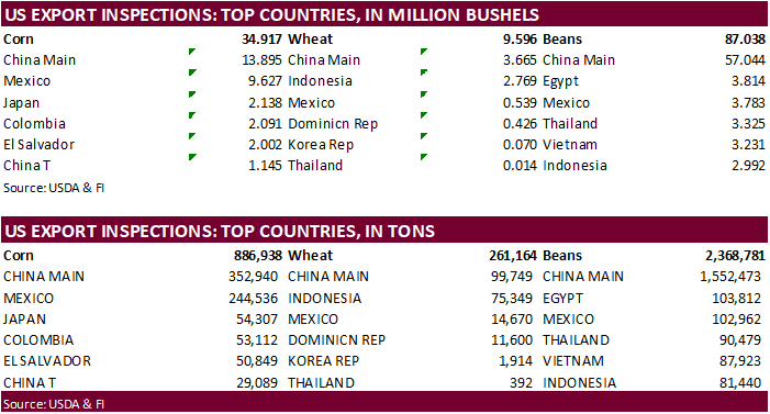
inspections versus Reuters trade range
Wheat
261,164 versus 375000-650000 range
Corn
886,938 versus 725000-1000000 range
Soybeans
2,368,781 versus 2050000-2650000 range

GRAINS
INSPECTED AND/OR WEIGHED FOR EXPORT
REPORTED IN WEEK ENDING DEC 10, 2020
— METRIC TONS —
CURRENT PREVIOUS
———
WEEK ENDING ———- MARKET YEAR MARKET YEAR
GRAIN 12/10/2020 12/03/2020 12/12/2019 TO DATE TO DATE
BARLEY
0 1,397 846 17,751 16,760
CORN
886,938 753,005 699,697 11,932,864 7,241,338
FLAXSEED
0 24 0 437 196
MIXED
0 0 0 0 0
OATS
998 0 798 2,393 2,295
RYE
0 0 0 0 0
SORGHUM
197,844 73,503 77,564 1,724,370 708,524
SOYBEANS
2,368,781 2,585,571 1,317,564 32,077,326 18,692,102
SUNFLOWER
0 0 0 0 0
WHEAT
261,164 536,881 512,778 13,733,327 13,567,944
Total
3,715,725 3,950,381 2,609,247 59,488,468 40,229,159
CROP
MARKETING YEARS BEGIN JUNE 1 FOR WHEAT, RYE, OATS, BARLEY AND
FLAXSEED;
SEPTEMBER 1 FOR CORN, SORGHUM, SOYBEANS AND SUNFLOWER SEEDS.
INCLUDES
WATERWAY SHIPMENTS TO CANADA.
Corn.
-
CBOT
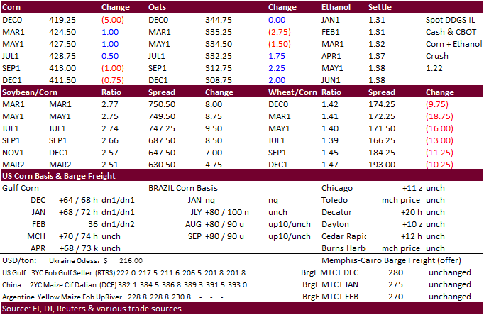
corn ended
slightly higher from higher energy markets and weakness in the USD, but the back months fell on lack of news. Slow Argentina corn registrations for export and hopes China will but more US corn were initially supporting futures. Global lock down concerns
are rising. Germany went back into a hard lock down over the weekend. London is going back into Tier 3 lock down and the Netherlands may soon announce a hard lock down as of Dec 16. -
The
USD was down 24 points and WTI up $0.36.
- Funds
bought an estimated net 1,000 corn contracts. - USDA
US corn export inspections as of December 10, 2020 were 886,938 tons, within a range of trade expectations, above 753,005 tons previous week and compares to 699,697 tons year ago. Major countries included China Main for 352,940 tons, Mexico for 244,536 tons,
and Japan for 54,307 tons.
-
Brazil’s
tariff-free ethanol import quota with the United States ended today as talks broke down. US tariff ethanol imports will go back to 20%. Note Brazil ethanol production is set to double this year.
-
BAGE
reported Argentina’s corn planting is over 50% complete. -
For
48 hours staring last Friday, South Korea ordered a nationwide standstill order for poultry farms to prevent the spread of bird flu disease.
-
Note
China will start trading hog futures January 8. Chinese New Year is next week, and traders are hoping China will be buying US corn and other feedgrains ahead of the holiday.
Domestic
Chinese pork prices are strengthening ahead of the holiday. -
The
EPA said they are aiming for Dec. 31 date to propose biofuel blending mandates. EPA will also aim to finalize the rule Renewable Volume Obligations in June 2021. The EPA missed the Nov. 30 deadline for issuing the obligations.
Corn
Export Developments
- None
reported
Source:
Trade News Service
Updated
11/30/20
March
corn is seen
trading in a $4.15 and $4.40 range.


