PDF Attached


Holiday
week.
Argentina
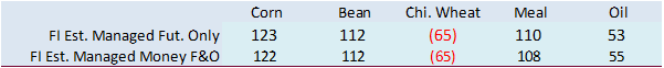
weather was in question.  Export inspections indicated a shift from soybeans to grains for exports. USD was slightly lower, spot. WTI crude oil higher and US equity futures mixed. CBOT ag markets are mixed to lower. Most ag markets were lower.


Weather

Argentina
may see rain this weekend. Brazil is in good shape, including the southern areas.


World
Weather, INC.

WORLD
COARSE GRAIN AND OILSEED AREAS 

BRAZIL

           
Timely rainfall is expected in most of the nation’s production region during the next two weeks. Some net drying is possible in the far south and parts of Paraguay, but crop conditions elsewhere should be good for normal crop development. Pockets of dryness
in the south and west should not be great enough to seriously impact nationwide production potentials and relief is probable in the second week of the outlook.

Past
Weather

  • Scattered
    showers and thunderstorms occurred in most of Brazil at one time or another Friday through Sunday
    • The
      exceptions were in western and southern Rio Grande do Sul and Paraguay which were dry
    • Rain
      from parts of Sao Paulo and southern Minas Gerais to eastern and southern Mato Grosso was less than 0.70 inch with many areas getting less than 0.30 inch resulting in net drying
    • Rainfall
      varied from 0.20 to 1.50 inches from northeastern Rio Grande do Sul from southern Mato Grosso do Sul and from northern Minas Gerais through southwestern Bahia and northern Goias to Tocantins
      • Local
        rain totals to 3.00 inches occurred in north-central Mato Grosso
  • Highest
    temperatures were in the 80s and lower 90s Fahrenheit Friday through Sunday
  • Lowest
    morning temperatures Saturday through today were in the 50s and lower 60s in the south and in the 60s and lower 70s in the north

Precipitation
Forecast

  • Week
    1 rainfall in southern Brazil (Mato Grosso do Sul to Rio Grande do Sul) will generate 0.20 to 0.75 inch of moisture with a few totals of up to 1.50 inches
    • Net
      drying is most likely, but after weekend rain fell in a part of this region crops should stay in mostly good shape
  • Week
    2 weather in southern Brazil will generate rain for most areas from Mato Grosso to Rio Grande do Sul with rainfall of 0.50 to 1.50 inches and local totals over 2.00 inches
  • Northern
    Brazil rainfall will occur frequently over the next two weeks with week 1 rain totals of 2.50 to 6.00 inches and local totals over 8.00 inches from Mato Grosso and Tocantins to Minas Gerais and Bahia
  • Northern
    Brazil Week 2 rainfall will range from 0.50 to 1.50 inches and local totals to 3.00 inches

Temperatures
Forecast

           
Near to slightly cooler-than-usual temperatures are expected during the next two weeks with daily highs in the 80s and lower 90s occurring most often followed by lows in the 60s and lower to middle 70s.


ARGENTINA

           
Argentina’s rainfall outlook is improved over that of Friday and Sunday. Rain is expected Friday into Sunday that will lift topsoil moisture and reduce crop stress, but follow up rain will be very important. The outlook is poised for some improvement to occur,
but additional follow up rainfall will be imperative to induce a true trend change. In the meantime, some increase in late season planting progress is expected and many crops will benefit from the boost in rainfall expected later this week and by the milder
temperature outlook slated for the weekend and next week.

Past
Weather

  • Weekend
    precipitation was mostly confined to northwestern and some west-central Argentina crop areas
    • Moisture
      totals varied from 0.30 to nearly 2.00 inches from central Chaco to Santiago del Estero and northwestern Cordoba
  • Dry
    conditions occurred elsewhere
  • Highest
    temperatures were in the upper 70s and lower 80s Fahrenheit in the southeast and in the 80s and lower 90s in most other areas
    • Some
      extreme highs reached the upper 900s to near 1009 in the far northwest of Argentina
  • Lowest
    morning temperatures were in the upper 4r0s and 50s southeast and in the 50s and lower 60s elsewhere


Precipitation
Forecast

  • Brief
    showers Tuesday and Wednesday producing up to 0.40 inch of rain – mostly in the west and south
    • Coverage
      of measurable rain will be around 30% each day
  • Rain
    Thursday through Sunday likely throughout the nation
    • Moisture
      totals of 0.40 to 1.50 inches and local totals to 2.50 inches
      • Wettest
        from Entre Rios to Cordoba
  • Additional
    showers and thunderstorms are likely Dec. 26-29
    • Daily
      rainfall of 0.15 to 0.60 inch with local totals of 0.80 inch
    • Coverage
      will be close to 80%

LOW
CONFIDENCE BEYOND THIS POINT

  • Dec.
    30-Jan. 2 isolated to scattered showers with daily coverage of 20-35% and most rain totals less than 0.50 inch

Temperature
Forecast

  • Warm
    weather is likely today into Thursday with daily highs in the 80s and lower to a few middle 90s Fahrenheit and lows in the 50s and 60s in the south and 60s and lower 70s in the north
  • Cooling
    is likely this weekend with highs in the upper 60s and 70s in the south and the upper 70s and 80s in the north with a few lower 90s possible as well
    • Low
      temperatures will be in the 60s and 60s
  • Temperatures
    will be near to below average Dec. 26-Jan. 2


U.S.
MIDWEST

           
A strong blast of bitter cold air will arrive during mid-week this week on very strong northerly wind speeds and periods of snow. The environment will likely bring some travel to a standstill. The environment will lead to frost bite and hyperthermia for folks
unprotected from the cold. Livestock stress and some death will be possible and energy demand will rise dramatically.

           
Winter wheat should be protected by snow that precedes the coldest weather.

Past
Weather

  • Snow
    fell lightly across parts of the northern Midwest Friday through Sunday
    • Accumulations
      varied from a dusting to 3 inches with a few exceptions
      • Most
        of the snowfall of 2-3 inches occurred in northeastern Iowa into Wisconsin
      • West-central
        and southwestern Michigan reported much heavier snow from Lake Effect conditions with snowfall of 6 to 14 inches resulting from near the Grand Rapids areas westward to Lake Michigan.
        • Moisture
          totals varied up to 0.40 inch in the Michigan heavy snowfall area
  • Highest
    temperatures Friday through Tuesday were in the 20s and 30s in northern parts of the Midwest while in the 30s and 40s in the lower Midwest
  • Lowest
    temperatures Saturday through today were in the negative teens and negative single digits in far northwestern parts of the Corn Belt to the single digits and teens in other northwestern crop areas
    • Lows
      in the teens and 20s were common elsewhere.

Precipitation
Forecast

  • Rain
    and snow are expected from Kansas and Missouri to Minnesota and Wisconsin today with only a few spotty showers possible in the Midwest Tuesday
    • Moisture
      totals will vary from a trace to 0.15 inch with a few amounts to 0.35 inch
      • Snowfall
        will not accumulate to more than 2 inches
  • Snow
    is likely in the western Corn Belt Wednesday into Friday with moisture totals of 0.10 to 0.75 inch with a few greater amounts from northwestern Illinois to southeastern Wisconsin
    • Snow
      accumulations of 4 to 10 inches will be  common with a few areas in that heavier precipitation band possibly getting 10 to 20 inches
  • Blizzard
    conditions are likely in the western Corn and Soybean Belt with wind speeds of 30-60 mph and possible higher gusts and falling temperatures along with the snow and blowing snow
    • Extreme
      wind chills are likely along with a wind chill warning and the risk of frost bite will be on the rise
  • Eastern
    Midwest precipitation will begin as rain and snow Thursday and then changing to all snow Friday into Saturday with lingering snow showers and flurries Sunday
    • Moisture
      totals of 0.15 to 0.75 inch and local totals to 1.25 inches will occur with greater amounts in northwestern Michigan
    • Snowfall
      will vary from 2 to 6 inches with a few areas of greater snow in parts of eastern Illinois, northwestern Indiana and western Michigan
      • Heavy
        snow is likely in northwestern Michigan
  • Dec.
    25-26 snow is expected in the Great Lakes region with light accumulations
  • Dec.
    28-29 showers of rain and some snow will occur with moisture totals rarely more than 0.25 inch
  • Dec.
    30-Jan. 2 will bring the next larger storm to the eastern Midwest, but confidence is low


U.S.
DELTA/SOUTHEAST

           
Freezes are expected in sugarcane areas of Louisiana late this week possibly inducing some crop damage. Hard freezes in the Delta and southeastern states will be good in controlling insects for the spring.

           
Rain and snow that precede the coldest weather will disrupt late season fieldwork, although most of this year’s harvest is complete.

Past
Weather

  • Not
    much precipitation fell during the weekend, although light rain did occur in parts of Louisiana, southern Mississippi and immediate neighboring areas with moisture totals to 0.15 inch
  • Highest
    temperatures were in the 40s and 50s in the north and in the 50s and 60s in the south
  • Lowest
    morning temperatures were in the 30s and 30s with freezes occurring southward to the interior southernmost parts of Louisiana, Mississippi and Alabama.

Precipitation
Forecast

  • Rain
    will fall in the lower Delta today and Tuesday with some of that expected in southern parts of the southeastern states Tuesday into Wednesday
    • Moisture
      totals of 0.40 to 1.60 inches with a few amounts over 2.00 inches
    • A
      trace to 0.30 inch is expected from the northern Delta into the Tennessee River Valley to northern Georgia and northern South Carolina
  • Rain
    will evolve in the southeastern states Thursday before changing to snow and ending Friday with 0.20 to 0.75 inch and local totals to 1.30 inches
  • Rain
    and snow will evolve in the Delta Thursday into Friday morning with moisture totals of 0.05 to 0.35 inch and local totals to 0.60 inch
    • Southeastern
      Missouri and western Tennessee will be wettest
  • Mostly
    dry Saturday through Dec. 29


LOW
CONFIDENCE BEYOND THIS POINT

  • Rain
    is likely Dec. 30-31 with 0.30 to 1.00 inch and locally more
  • Dec.
    31-Jan 1 rain will impact the southeastern states with 0.20 to 0.80 inch and locally more

Temperature
Forecast

  • High
    temperatures today and Tuesday will be in the 40s Fahrenheit
  • Highs
    will rise to the 40s and 50s Wednesday and some 50s and 60s in the south Thursday
  • Cooling
    Friday through Sunday will result in afternoon temperatures in the teens and 20s and lows in the single digits and teens
  • Warming
    is likely in the early days of January


AUSTRALIA


Late season harvesting of wheat, barley and canola will be periodically disrupted by showers this week, but most of the rainfall will not be heavy enough to seriously impact crop conditions. Showers in eastern Australia will be good for summer crop development
in unirrigated fields, although greater rainfall may still be needed in many of the driest areas.

Past
Weather

           
Most grain, oilseed and cotton production areas failed to receive significant precipitation during the Friday through Sunday period. However, showers in central Queensland produced 0.15 to 1.07 inches of rain. The moisture was welcome and mostly good for unirrigated
crop development, although more rain is still needed. Showers that occurred elsewhere in the nation were not significant and had a minimal impact on fieldwork, crop conditions and soil moisture.

           
Highest temperatures Friday through Sunday were in the 60s and 70s in Victoria, the upper 70s and 80s in New South Wales and southern Western Australia while in the 80s and lower 90s elsewhere. Lowest temperatures Friday through Sunday were in the upper 40s
and 50s in eastern parts of the nation while in the 50s and 60s in Western Australia.

Forecast
Weather

  • Showers
    will develop today in eastern South Australia and western New South Wales with rainfall to 0.50 inch
  • Showers
    in western New South Wales and western Victoria Tuesday will produce 0.05 to 0.60 inch of rain
  • Rain
    Wednesday and Thursday will vary from 0.10 to 0.60 inch with a few amounts to 0.75 inch in New South Wales, Victoria and a few southeastern Queensland locations
  • Rain
    Friday will linger in southeastern Queensland and northeastern New South Wales with another 0.05 to 0.35 inch and local totals to 0.75 inch
  • Saturday
    and Sunday rainfall will be sporadic and light with net drying in most of the nation
  • Dec.
    26-27 showers will be limited to eastern Western Australia and Western South Australia with rainfall of 0.10 to 0.75 inch
  • Dec.
    28-Jan 2 showers will impact 20-30% of Australia’s crop areas daily with rainfall of up to 0.60 inch each day

Temperature
Forecast

           
Temperatures will be near to above normal this week except in far eastern most parts of Australia where readings will be a little cooler than usual. Daily highs will vary in the 70s and 80s across much of the south with a few lower 90-degree highs. High temperatures
farther to the north will be in the 80s and lower to middle 90s followed by lows mostly in the 50s and 60s. A few upper 40-degree lows are possible in the south.


CHINA

Sichuan
and neighboring areas will see a mix of precipitation and sunshine this week. Precipitation totals will be too light to significantly bolster soil moisture in most locations. Northeast China will also see a mix of snow and sunshine. Eastern Heilongjiang will
receive significant snow with several centimeters of snow also accumulating from central Heilongjiang into Jilin.

The
remaining production areas in China will be drier biased this week. Winter rapeseed and winter wheat prospects will remain favorable in the Yangtze River Basin, North China Plain, and neighboring locations despite the lack of precipitation. Much of the crop
will remain dormant or semi-dormant.

Past
Weather

           
Coastal Guangdong reported 1.00-3.78″ of rain for the three-day period ending this morning. Several other areas in Guangdong into portions of Fujian, Zhejiang, Anhui, Jiangsu, and northern Jiangxi received 0.16-1.14″ of rain. Portions of Sichuan and western
Yunnan received 0.24-1.34″ of moisture. Little to no precipitation was noted elsewhere.

           
Highest temperatures December 16 – 18 peaked into the 60s and 70s Fahrenheit with pockets in the 50s in southern China. The Yangtze River Basin saw highest temperatures in the 40s and 50s. Highest readings in the North China Plain and central Yellow River
Basin were in the 30s and 40s with portions of Henan warming to the lower 50s. Central Inner Mongolia into Liaoning saw highest readings in the teens and 20s. Other areas in Northeast China saw highest readings in the negative and positive single digits with
pockets in the positive teens.

           
Lowest temperatures over the weekend and this morning were in the 30s and 40s in southern China. Lowest readings in the Yangtze River Basin were in the 20s and 30s. The North China Plain and central Yellow River Basin had lowest temperatures in the teens and
20s with pockets in the positive single digits. Central Inner Mongolia into Liaoning had lowest temperatures in the negative and positive single digits. Most other areas in Northeast China had lowest temperatures in the negative teens and single digits, though
northern Heilongjiang and northeastern Inner Mongolia had lowest temperatures in the negative 30s and 20s with pockets in the negative 40s.


Forecast
Weather

  • Sichuan
    and neighboring areas in Yunnan, Hubei, Shaanxi, and Guizhou will see a mix of precipitation and sunshine this week
    • Light
      precipitation will initially evolve overnight tonight into Tuesday
    • More
      precipitation will evolve later this week and weekend
    • Moisture
      totals by next Monday morning will range from 0.10-1.00″ and locally greater amounts
    • Snow
      will be possible in a few pockets, though accumulations will be minimal
  • Northeast
    China will see a mix of precipitation and sunshine this week as well
    • Much
      of the precipitation will evolve overnight tonight into Thursday as a disturbance passes over the region
    • Moisture
      totals by next Monday morning will range from 0.10-0.50″ with portions of southeastern Heilongjiang receiving 0.50-1.50″ of moisture
    • Snowfall
      will range from 1 to 6 inches with portions of southeastern Heilongjiang receiving 6 to 12 inches of snow and local amounts over 15 inches
  • The
    remaining production areas will be dry or mostly dry this week
    • Any
      precipitation that occurs will be too light to counter evaporation or impact long-term soil conditions
  • Areas
    near and south of the Yangtze River, along with Northeast China, will see a mix of light precipitation and sunshine December 27 – January 2
    • Other
      areas will be drier biased

Temperature
Outlook

           
Temperatures will trend near normal in much of China this week before cooling to seasonable or seasonably cold levels December 27 – January 2.

  • Daily
    highs in the Northeast provinces will be in the negative and positive single digits through Thursday
    • Portions
      of Liaoning and neighboring areas will also warm to the positive teens, most notably Tuesday, while pockets in northern Heilongjiang and northeastern Inner Mongolia only warm to the negative teens
    • Highs
      Friday into early next week will increase to the positive single digits and teens with pockets in the 20s
    • Lows
      will be in the negative teens and single digits with portions of Liaoning only cooling to the positive single digits and teens
      • Northern
        Heilongjiang and northeastern Inner Mongolia will also frequently cool to the negative 30s and 20s with pockets occasionally dropping below negative 40s
  • Daily
    high temperatures in the southernmost provinces will be in the 50s and 60s
    • Southern
      Yunnan and areas near the southern coastline will often warm to the 70s as well
    • Low
      temperatures will be in the 30s and 40s with pockets near the southern coastline only cooling to the 50s
  • Highs
    elsewhere will be in the 40s and 50s
    • However,
      many areas in the central Yellow River Basin and central Inner Mongolia will only warm to the 20s and 30s with pockets in the teens
    • Lows
      will be in the 20s and 30s with pockets south of the Yangtze River only cooling to the 40s
      • Portions
        of the central Yellow River Basin and central Inner Mongolia will also cool to the positive single digits and teens

INDIA

A
disorganized tropical disturbance will often promote erratic rainfall for portions of Tamil Nadu and Kerala this week. The most recent forecast models do not bring the disturbance into southern India during the work week, though the system may track closer
to the region over the weekend and early next week. Precipitation totals will be too light to promote any flooding during the next several days. Winter crop prospects will otherwise remain favorable for much of Tamil Nadu and southern Andhra Pradesh.

           
Other production areas in India will be mostly dry this week. The lack of rain will support a good environment for aggressive fieldwork. Winter crop prospects will also remain mostly good, though the driest areas in western and northern India would benefit
from timely rain.

Past
Weather

           
One location in eastern Maharashtra reported 0.20″ of rain for the three-day period ending this morning. Most other locations were dry. Highest temperatures December 16 – 18 peaked into the 80s and 90s Fahrenheit in southern India, Maharashtra, Gujarat, Telangana,
and neighboring areas. Highest readings elsewhere were in the 70s and 80s. Lowest temperatures December 16 – 18 were in the 60s and 70s in southern India and Gujarat. Lowest readings elsewhere were in the 40s and 50s with pockets in northern India cooling
to the upper 30s.

Forecast
Weather

  • A
    disorganized tropical disturbance will slowly advance over the Bay of Bengal this week
    • Scattered
      showers associated with the disturbance will reach portions of Tamil Nadu, Andhra Pradesh, and neighboring areas at times, most notably late this week and weekend
    • Coastal
      Andhra Pradesh and Tamil Nadu will receive 0.50-2.00″ of rain with locally greater amounts by next Monday morning
    • Other
      areas will receive 0.10-0.50″ of rain
  • The
    remaining production areas in India will be drier biased this week
    • Any
      rain that occurs will be lost to evaporation
  • Southern
    India will see a mix of rain and sunshine December 27 – January 2
    • Little
      to no rain will occur elsewhere

Temperature
Outlook

           
Temperatures will trend near to slightly above normal in much of India this week before trending near to slightly below normal December 27 – January 2. Daytime highs will peak to the 70s and 80s Fahrenheit with many areas in eastern, southern, and western
India often warming to the lower 90s. Low temperatures will be in the 60s and 70s with pockets in the 50s in southern India and neighboring areas in western and central India. Lows elsewhere will be in the 40s and 50s with pockets in the lower 60s.


Source:
World Weather INC


Bloomberg
Ag Calendar

Tuesday,
Dec. 20:

  • China’s
    third batch of November trade data, including soy, corn and pork imports by country
  • New
    Zealand global dairy trade auction
  • EU
    weekly grain, oilseed import and export data
  • Malaysia’s
    Dec. 1-20 palm oil exports

Wednesday,
Dec. 21:

  • EIA
    weekly US ethanol inventories, production, 10:30am
  • Weekly
    USDA Broiler Report

Thursday,
Dec. 22:

  • USDA
    weekly net-export sales for corn, soybeans, wheat, cotton, pork and beef, 8:30am
  • US
    cold storage data for beef, pork and poultry, 3pm
  • US
    red meat production, poultry slaughter, 3pm
  • Port
    of Rouen data on French grain exports
  • Sugar,
    cane and ethanol production data by Brazil’s Conab (tentative)

Friday,
Dec. 23:

  • ICE
    Futures Europe weekly commitments of traders report, 1:30pm (6:30pm London)
  • CFTC
    commitments of traders weekly report on positions for various US futures and options, 3:30pm
  • USDA
    hogs and pigs inventory, cattle on feed, 3pm

Monday,
Dec. 26:

  • HOLIDAY:
    US, UK, Australia, Hong Kong, Singapore, several other countries
  • CBOT
    hard open for nighttime session

Tuesday,
Dec. 27:

  • Malaysia
    Dec. 1-25 palm oil exports
  • HOLIDAY:
    UK, Australia, Hong Kong

Wednesday,
Dec. 28:

  • Weekly
    USDA Broiler Report

Thursday,
Dec. 29:

  • EIA
    weekly US ethanol inventories, production, 10:30am
  • Vietnam’s
    general statistics department releases monthly coffee, rice and rubber export data

Friday,
Dec. 30:

  • USDA
    weekly net-export sales for corn, soybeans, wheat, cotton, pork and beef, 8:30am
  • CFTC
    commitments of traders weekly report on positions for various US futures and options, 3:30pm
  • ICE
    Futures Europe weekly commitment of traders report, 1:30pm (6:30pm London)

Saturday,
Dec. 31:

  • Malaysia’s
    Dec. 1-31 palm oil export data by cargo surveyor AmSpec

Source:
Bloomberg and FI


Macros

Canadian
PPI (M/M) Nov: -0.4% (est -0.4%; prev 2.4%)

Canadian
PPI (Y/Y) Nov: 9.7% (prev 10.1%)

Canadian
Raw Materials Prices (M/M) Nov: -0.8% (est -1.3%; prev 1.3%)

Canadian
Raw Materials Prices (Y/Y) Nov: 8.0% (prevR 8.6%)


USDA
inspections versus Reuters trade range

Wheat

304,108

versus

200000-600000

range

Corn

743,420

versus

450000-900000

range

Soybeans

1,619,850

versus

1500000-2150000

range


               GRAINS INSPECTED AND/OR WEIGHED FOR EXPORT
                  REPORTED IN WEEK ENDING DEC 15, 2022
                            -- METRIC TONS --
 
-------------------------------------------------------------------------
                                                   CURRENT     PREVIOUS  
             ----------- WEEK ENDING ----------  MARKET YEAR  MARKET YEAR
  GRAIN      12/15/2022  12/08/2022  12/16/2021    TO DATE     TO DATE   
 
BARLEY              0           0           0        1,708       10,010  
CORN          743,420     517,417   1,002,287    7,902,389   11,352,436  
FLAXSEED            0           0         100          200          224  
MIXED               0           0           0            0            0  
OATS                0           0           0        6,486          300  
RYE                 0           0           0            0            0  
SORGHUM         3,953       4,168     317,339      360,974    1,552,003  
SOYBEANS    1,619,850   1,878,278   1,909,031   25,036,140   27,426,919  
SUNFLOWER           0           0           0        2,160          432  
WHEAT         304,108     219,358     233,747   11,440,600   11,655,557  
Total       2,671,331   2,619,221   3,462,504   44,750,657   51,997,881  


Corn

·        
CBOT corn futures
fell
Monday in part to lower soybeans and wheat as weather forecasts pumped some rain for Argentina this upcoming weekend. 

·        
Coceral sees a larger grain production for UK and EU, combined, for 2023, to 304.4 million tons for 2023 from a forecast of 285.1 million in 2022. Soft wheat alone was estimated to increase to 143.2 MMT from 140.7 million in 2022.

·        
January options expire Friday.

·        
Southern Brazil corn crop prospects are falling. StoneX estimated Brazil’s southern state of RGDS corn crop at 4.51 million tons (early crop), down from 5.38 million previous. Recall Conab cut corn production for several southern
states, for the first crop, in their latest supply update.

·        
China corn imports during November were 740,000 tons, down 5.8% from year ago. YTD are down 26.9 percent to 19.75 million tons.  The steep decrease for imports is not alarming given the stats bureau reported a larger production
that CASDE.

·        
USDA US corn export inspections as of December 15, 2022 were 743,420 tons, within a range of trade expectations, above 517,417 tons previous week and compares to 1,002,287 tons year ago. Major countries included China for 415,944
tons, Mexico for 211,291 tons, and Japan for 56,434 tons.


Export
developments.

·        
None reported


Updated
12/6/22

March
corn $6.00-$7.15 range.
May
$5.80-$7.10


Soybeans

·        
CBOT soybeans were lower following weakness in soybean meal related to Argentina precipitation forecasts for this upcoming weekend. SBO was higher on product spreading and higher energy prices. Not much has changed fundamentally
and traders are likely watching SA weather.

·        
USDA US soybean export inspections as of December 15, 2022 were 1,619,850 tons, within a range of trade expectations, below 1,878,278 tons previous week and compares to 1,909,031 tons year ago. Major countries included China for
1,109,604 tons, Mexico for 155,385 tons, and Italy for 91,332 tons.

·        
Dorab Mistry sees Malaysia’s palm oil production around 19 million tons for 2023 and Indonesia output to increase 1.5 million tons.  The Malaysian palm stocks are expected to fall below 2 million tons by the end of Q1 2023. Prices
were estimated in a range of 3,500 and 5,000 ringgit per ton from now until the end of May.

·        
Indonesia’s November Palm Oil Exports Fall 13.5% M/m: Intertek  (Bloomberg) — Exports fell to 2.7 million tons in Nov. from 3.1 million tons shipped in the previous month, cargo surveyor Intertek Testing Services says in an emailed
statement.

·        
(Bloomberg) — India’s oilmeal exports rose to 407,193 tons in November from 213,154 tons in October, according to the Solvent Extractors’ Association of India.

  • Rapeseed
    meal exports rose to 134,952 tons from 98,571 tons in October
  • Soymeal
    exports rose to 164,075 tons from 40,196 tons in October
  • Rice-bran
    extract exports rose to 55,888 tons from 34,305 tons in October


Export
Developments

·        
Turkey seeks 24,000 tons of crude sunflower oil on December 23 for delivery between January 2 and February 15, 2023.


Updated
12/16/22

Soybeans
– January $14.50-$15.10, March $14.15-$15.25

Soybean
meal – January $445-$485, March $4.00-$500

Soybean
oil – January 61.00-65.50 range
,
March 55.00-70.00


Wheat

·        
US wheat futures ended lower after additional ships were able to leave Ukraine despite lack of (some) power for several areas across the country.

·        
USDA US all-wheat export inspections as of December 15, 2022 were 304,108 tons, within a range of trade expectations, above 219,358 tons previous week and compares to 233,747 tons year ago. Major countries included Korea Rep for
85,150 tons, Japan for 65,809 tons, and Mexico for 40,877 tons.

·        
Paris March wheat was lower by 0.25 euro at 297.75 euros a ton.

·        
Egypt is looking at measures to cool inflation for food. Reuters noted “Egypt’s annual headline inflation hit 18.7% in November, according to official data, while core inflation, which strips out more volatile items, reached 21.5%.”

·        
Egypt wheat stocks are sufficient for 4.8 months. Nearly 4 million tons were imported so Far in 2022.

·        
Iraq’s trade ministry said they have enough wheat sufficient for 2 months of consumption. 460,000 tons is currently monthly consumptions. Look for them to float additional import tenders.

·        
Russia’s currency fell 2.9% at one point on Monday, a signal exports could increase for countries that can still finance grain shipments.


Export
Developments.

·        
Results awaited: Iraq seeks 50,000 tons of milling wheat on Sunda, December 18.


Rice/Other

·        
(Bloomberg) — The Philippines will import around 2.5 million tons of rice next year, smaller than the 2022 purchases as local harvests improve, an agriculture official said.

·        
South Korea’s Agro-Fisheries & Food Trade Corp. seeks 83,672 tons of rice from the United States for arrival in South Korea in 2023 between Feb. 1 and June 30. 

·        
Bangladesh seeks 50,000 tons of rice on December 21 for shipment with 40 days of contract signing.

·        
Bangladesh also seeks 50,000 tons of rice on December 27.


Updated
12/16/22

Chicago
– March $7.00 to $8.50

KC
– March 8.00-$9.50

MN
– March $8.50 to $
10.00


Terry Reilly

Senior Commodity Analyst – Grain and Oilseeds

Futures International
One Lincoln Center
18 W 140 Butterfield Rd.

Oakbrook Terrace, Il. 60181

W: 312.604.1366

treilly@futures-int.com

ICE IM: 
treilly1

Skype: fi.treilly


Description: Description: Description: Description: FImail


Trading of futures, options, swaps and other derivatives is risky and is not suitable for all persons.  All of these investment products are leveraged, and you can lose more than your initial deposit.  Each investment product is offered
only to and from jurisdictions where solicitation and sale are lawful, and in accordance with applicable laws and regulations in such jurisdiction.  The information provided here should not be relied upon as a substitute for independent research before making
your investment decisions.  Futures International, LLC is merely providing this information for your general information and the information does not take into account any particular individual’s investment objectives, financial situation, or needs.  All investors
should obtain advice based on their unique situation before making any investment decision.  The contents of this communication and any attachments are for informational purposes only and under no circumstances should they be construed as an offer to buy or
sell, or a solicitation to buy or sell any future, option, swap or other derivative.  The sources for the information and any opinions in this communication are believed to be reliable, but Futures International, LLC does not warrant or guarantee the accuracy
of such information or opinions.  Futures International, LLC and its principals and employees may take positions different from any positions described in this communication.  Past results are not necessarily indicative of future results.