PDF Attached
WASHINGTON,
December 28, 2020- Private exporters reported to the U.S. Department of Agriculture the following activity:
–Export
sales of 233,700 metric tons of soybeans for delivery to unknown destinations during the 2020/2021 marketing year; and
–Export
sales of 125,000 metric tons of soybeans for delivery to unknown destinations during the 2021/2022 marketing year.
–Export
sales of 149,572 metric tons of corn for delivery to unknown destinations during the 2020/2021 marketing year.
–Export
sales of 33,000 metric tons of soybean oil for delivery to unknown destinations during the 2020/2021 marketing year.
We
made some US acreage adjustments:
Corn
– from 91.8 to 92.0
Soybeans
– from 89.5 to 89.75
Spring
Wheat from 12.8 to 12.1 *
Durum
from 1.765 to 1.650 *
Hay
52.2 to 52.3
*Wheat
cash spreads suggest lower plantings plus new-crop corn and soybean prices have rallied
MOST
IMPORTANT WEATHER OF THE DAY
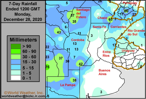
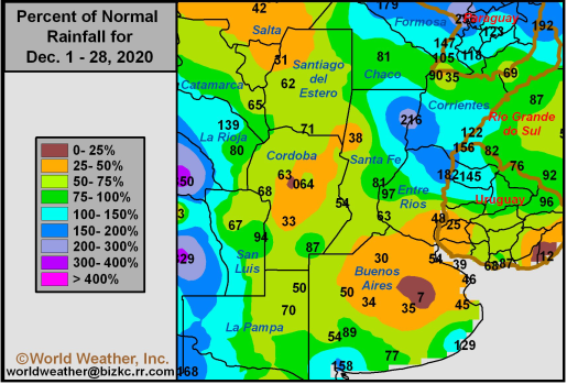
- Argentina
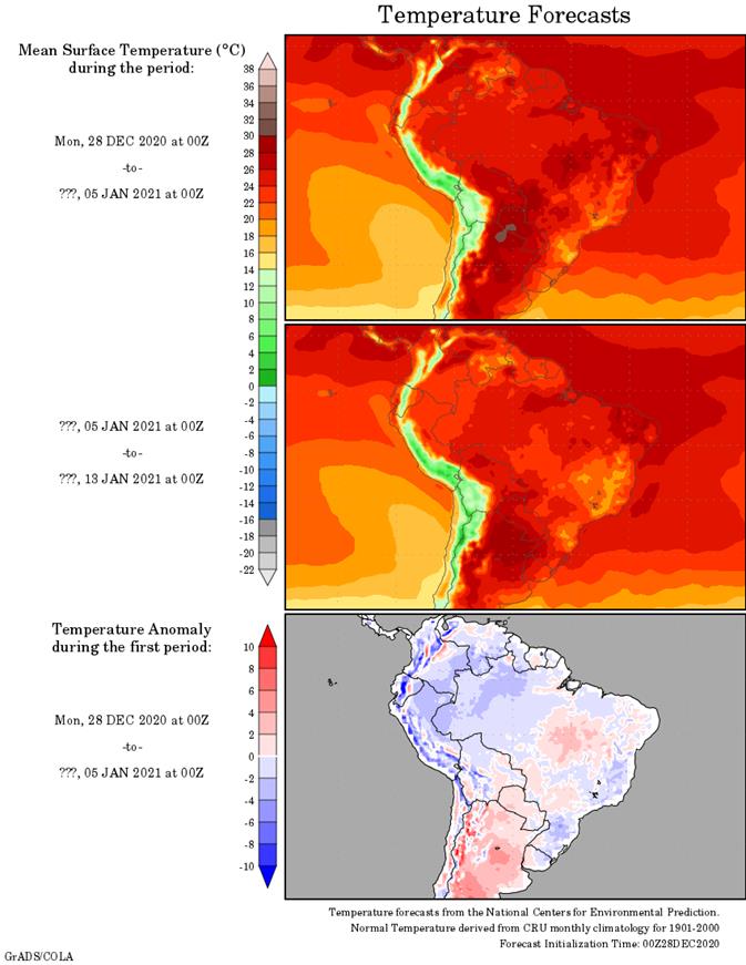
crop areas are too dry and limited rainfall this week coupled with very warm temperatures will raise the potential for further crop stress and rising concern over long term production potential - Argentina
weekend rainfall was limited to western and far northern crop areas – as expected - Some
of the rain was not enough to counter evaporation with highest temperatures in the 90s Fahrenheit to reading above 100 in the north - Brazil
will receive sufficient amounts of rain to support its center west and center south crops quite favorably over the next couple of weeks, but some net drying is expected at times in the far south and northeast raising a little concern over moisture stress - Weekend
rainfall in Brazil was concentrated on areas from Mato Grosso to western and southern Minas Gerais and Sao Paulo - The
moisture was sufficient to support crop development except in southern Goias where a few areas remained dry - Net
drying also occurred in much of southern Brazil and from northern Minas Gerais to Bahia where the need for rain is greatest - South
Africa rainfall will be erratic benefitting some crop areas more than others and a greater distribution of rainfall may be needed in the future - Dryness
remains most significant in a part of Free States while many other areas have favorable subsoil moisture - Recent
limited precipitation has allowed the topsoil to firm - Australia
rainfall will occur erratically in key grain and oilseed production areas over the next ten days bolstering soil moisture in some areas while maintaining dryness sin others - A
general boost in precipitation is needed to support long term crop development in unirrigated cotton and sorghum production areas especially in Queensland - Abundant
precipitation in western Russia and Ukraine recently as well as southeastern Europe has bolstered soil moisture and snow cover for crop use in the spring - There
is no threatening cold coming up in the next two weeks - Bitter
cold did occur in Russia’s eastern New Lands during the weekend with extreme temperatures to -48 Celsius (-54F)
- The
cold did not occur anywhere near winter crop areas - Some
of the bitter cold did reach into eastern Inner Mongolia, China where extremes fell to -43C - China
experienced net drying during the weekend, but precipitation this week is expected to be limited to the first half of the period with snow and rain impacting the Yangtze River Basin - Limited
precipitation is expected elsewhere, but winter crops are dormant and in mostly good shape - India
crop weather has been and will continue to be mostly good for agriculture - Some
showers will occur periodically in the far south and extreme north, but the earliest possible date for moisture in the heart of winter crop areas will hold off until Sunday and next week - Europe
will remain plenty moist over the next two weeks with frequent waves of rain and mountain snow anticipated
- Some
heavy rain and local flooding will impact southwestern France northern Spain, Italy and the eastern Adriatic Sea nations - Some
of these wetter areas will receive 2.00 to more than 6.00 inches of rain in the coming week - Temperatures
will be mild to cool in the west and warm in the east - Southwestern
Morocco remains in a drought with little relief expected for a while - Some
rain is possible early next week, but it will be brief and light - Northwestern
Algeria also has need for rain and it should get some of that briefly this week and again during the weekend - Soil
moisture in other North Africa crop areas is rated mostly good - U.S.
precipitation over the long holiday weekend was greatest in the Appalachian Mountains and areas east to the Atlantic Coast with rainfall of 0.70 to 2.33 inches with locally more in New England - Light
precipitation fell in the northern Midwest and northern Plains, but moisture continent was low - Frequent
precipitation impacted the Pacific Northwest while a few bouts of light rain and mountain snow occurred in California - Net
drying occurred in most other areas - Temperatures
were cold late last week and then trended warmer during the weekend - No
crop damaging cold occurred in Florida citrus areas with most of the lowest temperatures in the 30s Fahrenheit - U.S.
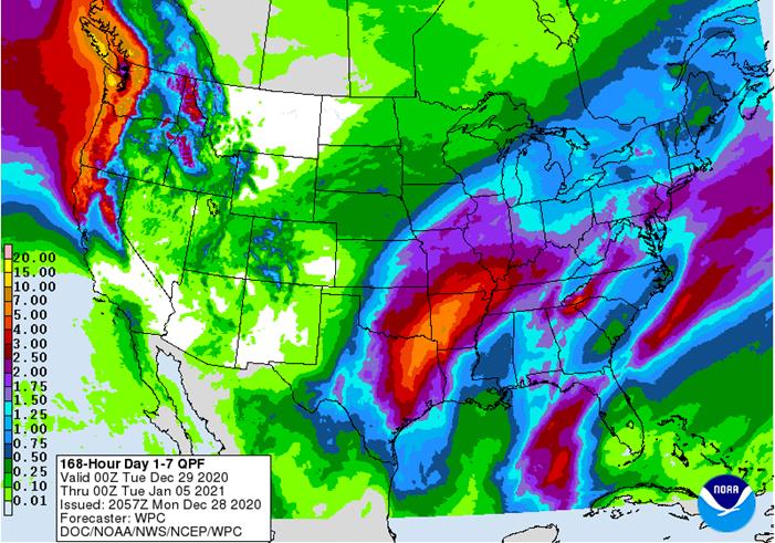
weather over the next couple of weeks will be most active in the central and eastern Midwest with three storms possible - First
storm is expected Tuesday and Wednesday of this week beginning in the central Plains Tuesday and impacting the Midwest Tuesday night into early Thursday - Moisture
totals of 0.20 to 0.80 inch with some 1.00 to 2.00-inch totals in the central and south
- Snowfall
of 2 to 8 inches will occur from Nebraska through Iowa and southern Minnesota to parts of Lower Michigan - There
is potential for a band of greater snow from eastern Iowa to northern Lower Michigan that could reach above 12 inches
- Second
storm will impact the eastern Midwest late Thursday and Friday with a little moisture lingering Saturday - Moisture
totals will vary from 0.30 to 0.80 inch in the northern Midwest and 1.00 to 2.50 inches and locally more in the south with significant freezing rain and sleet expected in the central and northern Midwest while a little snow falls in the northwest - Significant
icing is possible from eastern Iowa and northern Illinois to Southern Michigan with snowfall of 1 to 5 inches a little farther to the north and west from northern Missouri through eastern Iowa to parts of Wisconsin and Michigan
- Third
storm is expected January 6-8 that will produce rain and snow in the Midwest once again with a smaller band of freezing rain possible as well - One
more storm is advertised for the central Plains Jan. 8 and into the Midwest Jan. 9-10, but confidence is very low - U.S.
hard red winter wheat areas will be driest in the west-central and southwest during the next two weeks; However, some snow will fall tonight and Tuesday in Nebraska with a wintry mix of precipitation types in northern Kansas and a little light snow in Colorado - Snowfall
will range from 1 to 3 inches except in a few central Nebraska locations where up to 5 inches may result - Additional
rain will fall in southeastern parts of the wheat region briefly Thursday, but without much impact on crop areas - Another
mix of light precipitation will be possible Jan. 5-6, but with only light amounts in the high Plains region - The
bottom line leaves the high Plains region without much significant moisture, but some brief periods of light precipitation are possible without having much impact on the long term condition of crops and soil in the region - U.S.
northern Plains - No
major storms are expected in the next two weeks; only light snowfall will impact eastern parts of the region periodically - Snowfall
this week will be greatest tonight and Tuesday when 1 to 3 inches and local totals to 5 inches will impact South Dakota, the southeast half of North Dakota and Minnesota - There
is potential for more than 8 inches of snowfall in far southeastern South Dakota and southern Minnesota Tuesday - Not
much other “significant” precipitation is expected through mid-week next week - Far
southwestern U.S. crop areas will remain drier biased over the next two weeks, although a little shower activity is expected Tuesday into Wednesday with moisture totals of 0.05 to 0.35 inch except in the Rolling Plains of Texas where more than 0.60 inch will
result. - U.S.
Delta and southeastern states will remain plenty moist over the next two weeks with the greatest rain event expected in the Delta Wednesday through Friday of this week when some 1.00 to 2.50-inch amounts will be possible (wettest in the north). The southeastern
states will experience rainfall of 0.75 to 2.00 inches - Another
weather system will occur in the latter part of next week - U.S.
Pacific Northwest will experience frequent waves of rain and mountain snowfall during the next couple of weeks - Waves
of rain and mountain snow will fall across the Sierra Nevada with periods of rain in northern California over the next two weeks - The
precipitation will help improve soil moisture and mountain snowpack for better crop use in the spring - Snowpack
in the Sierra Nevada is well below average running close to the record low of 2014, but that will soon change - Waves
of heavy rain are expected in the Philippines and along the central and lower Vietnam coast over the next ten days - More
flooding is possible in each of these areas - Not
much more than scattered light showers will occur infrequently in Vietnam’s Central Highlands where it has been rainy in recent weeks - Weekend
rainfall in Southeast Asia was greatest in central and eastern parts of the Philippines, in the Malay Peninsula and across random locations in Indonesia and Malaysia - Rainfall
of 1.18 to near. 3.50 inches occurred in the Philippines with one amount of 4.64 inches in northwestern Mindanao
- Rainfall
in the southern Malay Peninsula reached over 5.00 inches while one location in the north reached over 6.00 inches - Amounts
in between were less than 3.50 inches with a few areas getting less than 0.50 inch - Indonesia
and Malaysia rainfall varied widely with some 1.00 to 2.00-inch totals with local amounts of 2.00 to 4.25 inches while a few others reported less than 0.50 inch - West
Africa rainfall during the weekend and that of this week will remain mostly confined to coastal areas while temperatures in the interior coffee, cocoa, sugarcane, rice and cotton areas are a little warmer than usual - East-central
Africa rainfall will continue limited in Ethiopia as it should be at this time of year while frequent showers and thunderstorms impact Tanzania, Kenya and Uganda over the next ten days - Southern
Oscillation Index remains very strong during the weekend and was at +16.32 this morning – its highest values of the current La Nina episode - Mexico
and Central America weather during the long weekend was mostly dominated by showers and thunderstorms near the Gulf of Mexico and Caribbean Sea coasts - Temperatures
were cold in Mexico with frost and freezes noted in many central and northern Mexico locations - Little
to no crop damage resulted - Not
much change is expected
Source:
World Weather Inc. and FI
Monday,
Dec. 28:
- USDA
export inspections - COT
report
Thursday,
Dec. 31:
- U.S.
Export Sales Report will be released on Thursday, December 31, 2020.
Source:
Bloomberg and FI
USDA
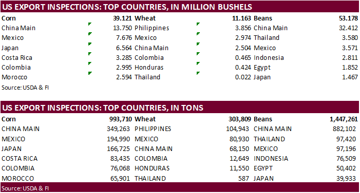
inspections versus Reuters trade range
Wheat
303,809 versus 300000-500000 range
Corn
993,710 versus 700000-950000 range
Soybeans
1,447,261 versus 1625000-2500000 range

GRAINS
INSPECTED AND/OR WEIGHED FOR EXPORT
REPORTED IN WEEK ENDING DEC 24, 2020
— METRIC TONS —
————————————————————————-
CURRENT PREVIOUS
———–
WEEK ENDING ———- MARKET YEAR MARKET YEAR
GRAIN 12/24/2020 12/17/2020 12/26/2019 TO DATE TO DATE
BARLEY
3,193 0 0 20,944 16,760
CORN
993,710 770,122 408,946 13,734,004 8,052,178
FLAXSEED
24 0 100 461 396
MIXED
0 0 0 0 0
OATS
0 0 0 2,393 2,295
RYE
0 0 0 0 0
SORGHUM
205,768 205,923 4,049 2,137,310 869,974
SOYBEANS
1,447,261 2,805,077 991,801 36,482,110 20,780,841
SUNFLOWER
0 0 0 0 0
WHEAT
303,809 392,178 312,316 14,431,786 14,486,637
Total
2,953,765 4,173,300 1,717,212 66,809,008 44,209,081
————————————————————————
CROP
MARKETING YEARS BEGIN JUNE 1 FOR WHEAT, RYE, OATS, BARLEY AND
FLAXSEED;
SEPTEMBER 1 FOR CORN, SORGHUM, SOYBEANS AND SUNFLOWER SEEDS.
INCLUDES
WATERWAY SHIPMENTS TO CANADA.
CFTC
Commitment of Traders report
The
trade missed the funds positions for soybeans and corn by a very large amount. Chicago wheat, meal and soybean oil were also less long than expected.

SUPPLEMENTAL
Non-Comm Indexes Comm
Net Chg Net Chg Net Chg
Corn
297,888 19,173 399,550 5,605 -676,759 -25,356
Soybeans
178,243 12,675 179,658 2,420 -358,792 -16,815
Soyoil
77,577 4,916 123,391 -1,667 -223,014 -3,866
CBOT
wheat -21,540 -3,418 133,160 -629 -96,964 1,578
KCBT
wheat 30,797 -735 70,407 480 -100,798 1,212
=================================================================================
FUTURES
+ OPTS Managed Swaps Producer
Net Chg Net Chg Net Chg
Corn
265,713 15,454 243,890 -3,392 -641,500 -18,078
Soybeans
188,623 -1,595 100,702 -1,540 -351,975 -14,160
Soymeal
83,385 6,179 67,353 -1,342 -203,050 -12,511
Soyoil
101,253 3,534 88,457 -1,055 -233,265 -2,580
CBOT
wheat 6,233 -438 81,164 -61 -85,639 1,453
KCBT
wheat 51,544 -1,068 44,094 1,566 -98,142 -303
MGEX
wheat 2,420 -969 2,733 -34 -12,336 -172
———- ———- ———- ———- ———- ———-
Total
wheat 60,197 -2,475 127,991 1,471 -196,117 978
Live
cattle 47,698 6,430 67,721 -498 -129,375 -6,769
Feeder
cattle 3,358 835 7,665 22 -4,215 111
Lean
hogs 32,854 1,109 49,114 362 -76,760 1,882


Corn.
-
March
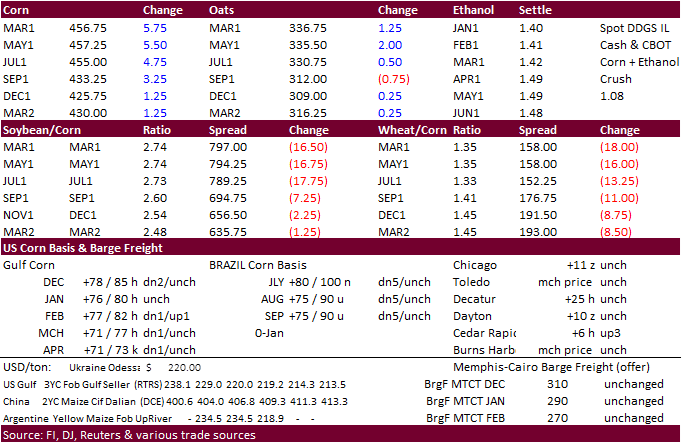
corn rallied 5.50 cents on unwinding of soybean/corn spreading and persistent dry weather expected for Argentina. USDA 24 hour sales announcements added to the positive undertone.
-
Argentina
saw welcome rains across the western and northern areas, but BA and La Pampa remained on the drier side. Argentina temperatures will be very hot this week adding to crop stress.
-
US
corn inspections fell just below 1 million tons, but this tends to be a slow time of year for physical shipments.
Corn
Export Developments
-
Qatar
seeks 100,000 tons of bulk barley on January 12.
- Qatar
seeks 640,000 cartons of corn oil on January 12. - USDA
24-hour sales:
–Export
sales of 149,572 tons of corn for delivery to unknown destinations during the 2020/2021 marketing year
Updated
12/21/20
March
corn is seen
trading in a $4.25 and $4.55 range.
