PDF attached
Good morning.
Private
exporters reported sales of 1,020,000 metric tons of corn for delivery to China. Of the total, 680,000 metric tons is for delivery during the 2021/2022 marketing year and 340,000 metric tons is for delivery during the 2022/2023 marketing year.
The
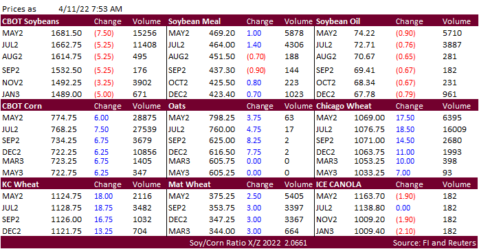
Ukraine/Russia situation is sending wheat higher, lending support to corn. Russia is sending additional personal to Ukraine. The CBOT soybean complex was mixed early this morning with soybeans lower, meal higher, and soybean oil lower. Offshore values with
exception pf palm, were leading SBO sharply lower. WTI crude oil was trading down about $4.40 at the time this was written and USD up about 11 points. MPOB reported palm oil stocks at 1.473 million tons, near one year low, and 53,200 tons below expectations.

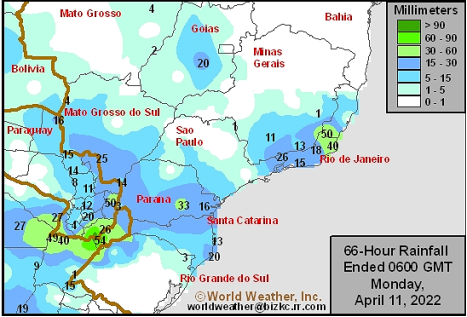
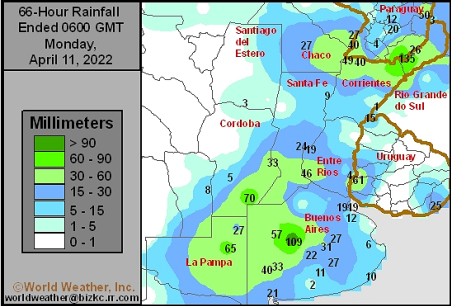
Source:
World Weather Inc.
WEATHER
EVENTS AND FEATURES TO WATCH
-
Northern
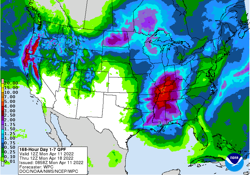
U.S. Plains, upper U.S. Midwest and southeastern Canada’s Prairies will be impacted by a major winter-like storm this week producing blizzard conditions and resulting in travel delays and a serious risk to livestock -
The
storm is expected Monday night into Thursday impacting most areas from Montana and northeastern Wyoming to Minnesota, southern Manitoba, Canada and possibly the extreme southeastern corner of Saskatchewan (Tuesday and Wednesday will be stormiest)
-
Moisture
totals will vary from 0.20 to 0.75 inch in Montana – away from the Canada border – and 0.50 to 1.50 inches with a few areas getting close to 2.00 inches in the eastern Dakotas, Minnesota and Manitoba
-
Snowfall
will vary from 4 to 10 inches in southeastern Montana and northwestern South Dakota while 8 to 20 inches occur across North Dakota, northern Minnesota and southern Manitoba -
Some
areas from eastern North Dakota to northern Minnesota and southern Manitoba, Canada will get 20-30 inches of snow -
Extreme
Blizzard conditions could threaten livestock and travel will be delayed
-
Flooding
will worsen on some rivers and streams in the Red River Basin because of rain and melting snow over saturated land and some rivers and streams are still in flood following the recent snow melt.
-
A
weak follow up disturbance may bring a little more snow and rain to the northern U.S. Plains and southeastern Canada’s Prairies late this week into the weekend, but its impact will be minimal -
U.S.
Delta, lower Midwest and Tennessee River Basin are still expecting brief periods of rainfall this week, although temperatures will be warmer for a little while -
Pockets
of net drying are still possible (especially early this week), but many areas will get just enough rain to limit drying rates and field progress -
The
greatest rainfall will occur as a cold front moves through the region Wednesday into Thursday at which time some severe thunderstorms are expected -
Rainfall
by Thursday will vary from 0.05 to 0.60 inch from southeastern Missouri to the Great Lakes region while 0.50 to 1.50 inches and a few totals over 2.00 inches are expected from the Delta to parts of Indiana
-
Temperatures
will be in the 60s and 70s Fahrenheit today over the lower Midwest, 60s Monday and back to the 70s Tuesday and Wednesday before cooling occurs late this week
-
U.S.
Midwest and Delta weather next week will start off with a new storm system Sunday into Monday that will push out of the region quickly leading to several days of net drying -
Fieldwork
may be possible in the second half of next week if there are no changes in next week’s weather outlook, although temperatures will be cool early in the week limiting drying rates -
The
best drying will come late in the week when warming is most likely -
Chilly
temperatures were noted this (Sunday) morning in the southeastern United States with 30-degree readings in many areas north of Florida with a few reports of frost and freezes from northern Georgia and northeastern Alabama into South Carolina and areas north
into Virginia and the lower Midwest -
Some
minor crop damage may have occurred, but most of the cold should not have had much impact -
Southeastern
U.S. rainfall will be minimal this week allowing soil conditions to dry out and planting to increase -
Some
brief rainfall is expected Thursday with some follow up rainfall Friday into Saturday -
The
mix of weather will be ideal for winter crop development and spring planting and emergence
-
Temperatures
will slowly warm with 70s and 80s Fahrenheit likely this week -
Southwestern
U.S. hard red winter wheat areas are unlikely to receive significant rainfall during the next two weeks -
Rainfall
in western Kansas and eastern Colorado will not be more than 0.30 inch occurring from sporadic rainfall as weather systems pass by to the north -
Temperatures
will be very warm to hot today and again Tuesday -
High
temperatures Tuesday will be in the 80s and 90s accelerating drying rates across the region
-
Cooling
will return more seasonable temperatures for Wednesday into Saturday with highs in the 40s and 50s in the north and 60s and lower 70s in the south -
Western
parts of U.S. hard red winter wheat will experience strong wind speeds and low humidity Monday and especially Tuesday afternoon accelerating the region’s plight to low soil moisture.
-
California’s
Sierra Nevada will receive two brief bouts of precipitation this week; one Monday and the other Thursday into Friday, but resulting moisture will not be great enough to seriously bolster snowpack of change spring runoff potentials -
Most
of the southwestern United States will continue dry over the next two weeks -
West
Texas should be dry for the next ten days and probably for two weeks -
South
Texas precipitation will be limited over the next ten days with areas near and south of Corpus Christi getting less than 0.50 inch of moisture, but areas farther north through the upper coastal area will get some greater rainfall -
The
greatest potential for rain in South Texas will occur next week -
Canada’s
Central and western Prairies are not expected to get much precipitation in the coming ten days -
Ontario
and Quebec will experience routinely occurring precipitation this week maintaining moisture abundance. -
Significant
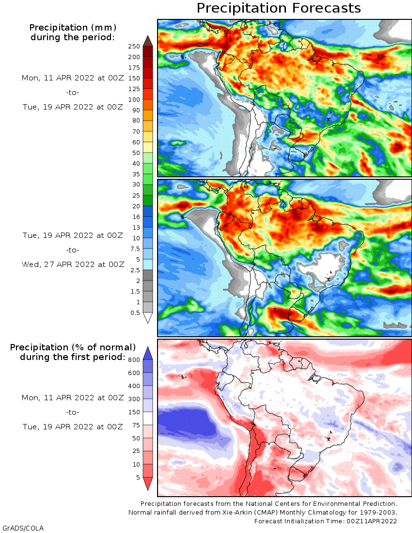
rain occurring today in northeastern Argentina will advance into interior southern Brazil and southern Paraguay later today and continue into Tuesday -
Areas
from northeastern Santa Fe and southeastern Chaco, Argentina through western and northern Rio Grande do Sul today will impact southern Paraguay, northern Rio Grande do Sul and southern Parana Monday and impact parts of Mato Grosso do Sul and Parana Tuesday
and Wednesday with some rain reaching into Sao Paulo and southwestern Mato Grosso Wednesday as well.
-
The
precipitation will diminish to sporadic showers of light intensity as the moisture moves farther to the northeast late this week -
Rain
totals of 1.50 to more than 4.00 inches will be common and a few areas may get 4.00 to nearly 6.00 inches
-
This
event will bring welcome relief to drying in Mato Grosso do Sul and “southern” Mato Grosso restoring saturated topsoil moisture and ensuring Safrinha corn and cotton have favorable soil moisture into late April even though dry weather is expected from this
coming weekend into April 20. Rain will return to southern Brazil after April 23.
-
Not
all of Mato Grosso, Brazil will get significant rain this week -
Central
Mato Grosso to southern Goias will only get 0.20 to 0.60 inch of moisture which may allow for additional drying -
Topsoil
conditions in this region were rated slightly short of moisture Friday while subsoil moisture was rated adequate -
Greater
rain must fall in this region to ensure the best conditions for Safrinha corn and cotton will continue during late April and especially May when reproduction is most likely -
Relief
is expected from dryness in Minas Gerais this week, but parts of Bahia and extreme northern Minas Gerais may prevail stressing minor corn, soybean, coffee and sugarcane areas that are not irrigated -
Rain
in Argentina was most significant Saturday night and early Sunday from northeastern La Pampa through west-central and southwestern Buenos Aires where rainfall varied from 0.45 to 1.00 inch with locally more in northeastern La Pampa.
-
Limited
rainfall occurred elsewhere, although thunderstorms were developing today in northeastern Argentina -
Weekend
rainfall in central and southern Argentina will be quick to abate today and early Monday with additional rainfall of 0.10 to 0.75 inch with a few amounts in the far south reaching over 1.50 inches.
-
Additional
heavy rain in northeastern Argentina today into Tuesday morning will result in some local flooding and possible crop damage -
Rain
will return to this region during mid-week next week with some heavy rain “possible” again after April 22 -
Confidence
is low -
Argentina
will experience net drying from Tuesday of this week to Tuesday of next week
-
Showers
during mid-week next week should be light and brief -
Argentina’s
bottom line will remain mostly good, but some pockets of dryness are expected in the west and central crop areas which may accelerate late season crops to maturity faster than usual because of moisture stress. Most crops in the nation are unlikely to be seriously
stressed by the drier biased conditions. Rain will be needed soon in Cordoba and areas east into central Santa Fe.
-
Tropical
Storm Megi produced torrential rainfall in Samar and some neighboring islands of east-central Philippines during the weekend. -
Rain
totals through 0001 GMT today (Sunday) in Samar ranged from 2.25 to 11.18 inches, but there may have been some greater amounts
-
The
storm was still located very near to southern Samar and was expected to produce additional heavy rain while it slowly dissipates and drifts aimlessly in the same region over the next few days -
Another
5.00 to 15.00 inches of rain may impact a part of the Philippines by midweek -
Tropical
Storm Malakas will become the season’s first typhoon between Guam and the Philippines this week.
-
The
storm will stay away from land throughout this week and will reach its peak intensity during mid-week
-
Malakas
may pass to the northwest of the island Iwo To late this week -
Europe
will experience less precipitation over the next ten days and a seasonable range of temperatures -
Totally
dry weather is not likely, but precipitation should be light and relatively infrequent -
The
environment will be very good for fieldwork in time as soil temperatures rise -
Western
Russia, Ukraine, Belarus and the Baltic States will experience brief periods of rain and snowfall during the next two weeks and temperatures should average relatively near normal with a slight cooler bias west of the Ural Mountains at times -
snow
cover will continue to retreat from western and northern Russia -
runoff
from melting snow will continue to keep some areas wet this week, despite more limited precipitation
-
North
Africa will experience a favorable mix of rain and sunshine during the next ten days while temperatures are seasonable -
India’s
weather will continue mostly dry in the bulk of the nation, but some occasional rain will occur in Kerala, and a few areas in both southern Karnataka and Tamil Nadu with minimal impacts on the region away from the coast -
Rain
will also continue frequently from eastern Bangladesh through the Eastern States -
West-central
Africa precipitation is expected to be more frequent and more significant over the next ten days to two weeks improving soil moisture for coffee, cocoa, sugarcane, rice and cotton
-
East-central
Africa rainfall is expected to slowly increase in Ethiopia, Uganda and southwestern Kenya during the next ten days with next week wettest -
The
change will be most welcome in Ethiopia where the dry season is coming to an end -
Turkey
will experience a good mix of rain while areas to the southeast from Syria through Iraq are dry and only limited rain is expected in Iran -
These
drier areas could experience some hot and dry weather in the next few weeks -
China
weather is expected to see typical spring weather over the next two weeks -
Rainfall
will be greatest near and south of the Yangtze River -
Precipitation
will be sporadic and mostly light in the North China Plain, Yellow River Basin and interior portions of the northeast -
Xinjiang,
China precipitation will be mostly confined to the mountains this week and next week
-
Temperatures
will be warmer than usual -
Australia
rainfall during the weekend was greatest in central cotton areas of New South Wales and south-central Queensland -
Rainfall
ranged from 1.00 to 3.45 inches in the heart of New South Wales cotton areas possibly reducing cotton fiber quality and stringing some fiber out of bolls -
Some
strong to severe thunderstorms were possible as well and that might have induced some additional crop damage -
Most
of the Queensland rainfall affected only a small part of crop country and the impact was low on crops
-
Drying
is needed and expected this week -
Australia
precipitation is expected to be mostly limited to coastal areas over the next ten days -
The
environment will be good for maturing cotton and sorghum as well as their harvests -
South
Africa rainfall over the next couple of weeks may be a little too frequent for some early season summer crop maturation and harvest progress -
Late
season crops will benefit, but there is need drying to accelerate maturation and support harvest progress -
Cotton
quality could be compromised -
Rain
will fall frequently and abundantly near and north of the Amazon River into Colombia, Venezuela and Ecuador during the next ten days -
Rain
will also fall frequently in Peru -
Some
flooding could impact a part of the Amazon River System and Colombia in time -
Mexico’s
winter dryness and drought have been expanding due to poor precipitation resulting from persistent La Nina -
Northern
parts of the nation will continue lacking precipitation for an extended period of time -
Eastern
and southern Mexico will be seasonably dry this week and will receive sporadic rainfall of limited significance next week -
Central
America precipitation will be greatest in both Panama and Costa Rica -
Guatemala
and western Honduras will also get some showers periodically -
Rain
elsewhere will be mostly along the Caribbean Sea coast -
Southeast
Asia rainfall will continue frequent and abundant -
No
area in the mainland areas, Philippines, Indonesia or Malaysia are expected to be too dry -
Too
much rain may impact east-central Philippines and a part of the northern Malay Peninsula this week -
Today’s
Southern Oscillation Index is +12.90 -
The
index will continue moving higher for a while this week
Source:
World Weather Inc.
Bloomberg
Ag Calendar
- USDA
export inspections – corn, soybeans, wheat, 11am - Malaysian
Palm Oil Board’s data for March output, exports and stockpiles - Malaysia’s
April 1-10 palm oil export data - Brazil’s
Unica may release sugar output and cane crush data (tentative) - U.S.
crop progress and planting data for corn and cotton; spring wheat progress, 4pm - Ivory
Coast cocoa arrivals
Tuesday,
April 12:
- France
Agriculture Ministry report; 2022 crop plantings - EU
weekly grain, oilseed import and export data - U.S.
winter wheat condition, 4pm
Wednesday,
April 13:
- EIA
weekly U.S. ethanol inventories, production, 10:30am - China’s
first batch of March trade data, incl. soybean, edible oil, rubber and meat imports - FranceAgriMer
report; monthly French grains outlook - New
Zealand food prices - Holiday:
Thailand
Thursday,
April 14:
- USDA
weekly net-export sales for corn, soybeans, wheat, cotton, pork and beef, 8:30am - May
ICE white sugar contract expiry - HOLIDAY:
Argentina, India, Thailand
Friday,
April 15:
- ICE
Futures Europe weekly commitments of traders report - CFTC
commitments of traders weekly report on positions for various U.S. futures and options, 3:30pm - U.S.
green coffee stockpiles data released by New York-based National Coffee Association - FranceAgriMer
weekly update on crop conditions - HOLIDAY:
Major markets closed due to Good Friday holiday
Source:
Bloomberg and FI
CFTC
Commitment of Traders
Traders
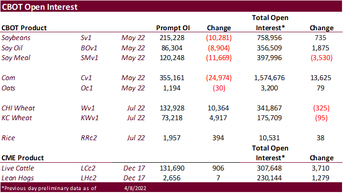
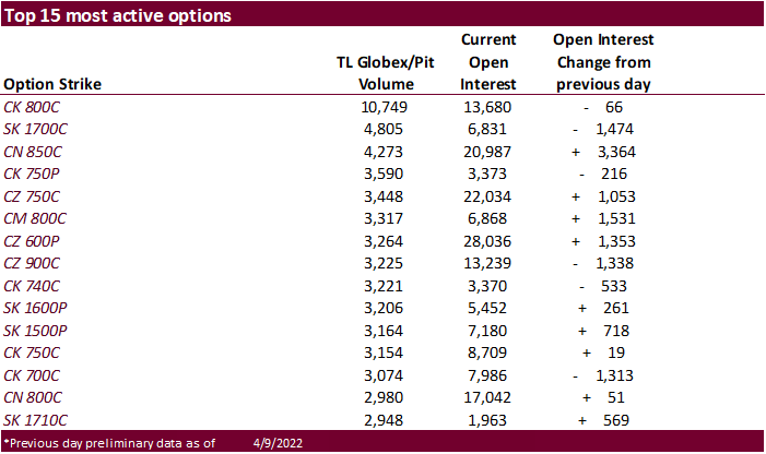
again missed the Chicago wheat let long position estimate and were way off for the corn position. Note open interest was up more than 108,000 contracts for corn combined futures and options.


·
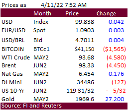
The Ukraine/Russia situation is sending wheat higher, lending support to corn. WTI and RBOB was sharply lower. Some speculate the China covid lockdowns are weighing on WTI crude oil, while others noted country releases of strategic
reserves. Charts for that market look bearish. Crude oil has now given up most of the gains seen since Russia’s invasion of Ukraine.
·
Russia is sending additional personal to Ukraine.
·
December corn hit a new contract high of $7.2325 and is up 6 out of the past 8 days.
·
France culled over 13 million poultry bids due to bird flu since the end of November. This is the worst outbreak for France in history.
·
China is pushing for the country to produce their own new seed varieties to boost production.
·
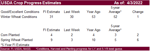
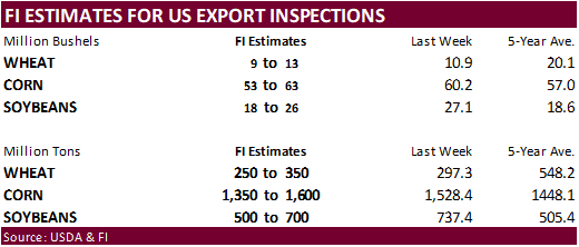
We look for USDA to report US corn plantings at 4 percent complete, up from 2 percent as of last Sunday.
Export
developments.
·
None reported
·
The CBOT soybean complex was mixed early this morning with soybeans lower, meal mixed (bull spreading), and soybean oil lower. WTI crude oil was trading down about $4.20 at the time this was written and USD up about 10 points.
Argentina and Brazil saw welcome precipitation over the weekend.
·
Offshore values with exception pf palm, were leading SBO sharply lower.
·
Truckers in Argentina started an indefinite strike today over wages. No end date was set. “There are no negotiations currently underway,” according to Federation of Argentine Transporters (FETRA).
·
Palm oil futures are near a two-week high.
·
MPOB reported palm oil stocks at 1.473 million tons, near one year low, and 53,200 tons below expectations. Production was higher than expected but exports coming in 98,000 tons and lower than expected exports trimmed stocks by
78,300 tons from end of February.
·
Cargo surveyor AmSpec reported Malaysian April 1-10 palm exports at 271,201 tons, compared to 370,492 tons a month ago.
·
Cargo surveyor ITS reported Malaysian palm exports at 278,621 tons, 26 percent below 371,422 tons from the same period a month ago.
·
June Malaysian palm oil settled 84 ringgit higher to 6,005. Cash palm was up $20 at $1,530 per ton.

·
China May soybeans increased 0.5 percent, meal was up 2.0 percent, palm up 0.9 percent and palm up 1.1 percent.

·
Rotterdam vegetable oil prices were unchanged to 13 euros lower and meal 5-9 euros higher.
·
Offshore values were leading soybean oil 158 points lower and meal $0.30 lower.

·
China plans to auction off another 500,000 tons of soybeans later this week.
·
The Ukraine/Russia situation is sending wheat higher. Chicago is near a two week high.
·
China sold 527,622 tons of wheat late last week from reserves, 95.4 percent of wheat was offered, at an average price of 2,709 yuan per ton, or $425.88//ton.
·
Ukraine’s grain union announced exports will be allowed to export of 600,000 tons of grain and oilseeds a month. New routes to export grain and oilseeds out of Ukraine are still getting worked out. Before the war, Ukraine exported
up to 6 million tons of grain and oilseed a month.
·
The Ukraine union estimate wheat production could drop 45 percent to 18.2 million tons and corn down 38 percent to 23.1 million.
·
SovEcon estimates Russia’s April exports of wheat, barley and corn at 2.10 million tons, down from 2.65 million tons in March.
·
IKAR reported 12.5% protein Russian wheat export prices at $368/ton fob, about unchanged from the previous week. SovEcon reported $370-$380/ton.
·
This week the US will see a large storm bring heavy snow to the upper Great Plains and risk for threatening weather for the upper Midwest.
·
We look for a one point improvement in the US combined good and excellent conditions to 31 percent, bias an increase in Midwestern states and Texas.
·
Earlier May Paris wheat futures were up 2.75 euros at 375.25 euros.
·
Russia set their export tax for wheat at $101.40 for the April 13-19 period, up from $96.10 previous.

University
of Illinois: Argentina and Brazil Could Expand Wheat Production Due to the War in Ukraine
Colussi,
J., G. Schnitkey and S. Cabrini. “Argentina and Brazil Could Expand Wheat Production Due to the War in Ukraine.”
farmdoc daily (12):48, Department of Agricultural and Consumer Economics, University of Illinois at Urbana-Champaign, April 8, 2022.
·
Results are awaited for Bangladesh in for wheat for shipment within 40 days after contract signing. Lowest price offer assessed at $399.19 a ton CIF liner out.
·
Algeria floated another import tender for wheat on April 12. The wheat is sought for shipment in several periods from the main supply regions including Europe: May 1-10, May 11-20, May 21-31, June 1-10, June 11-20 and June 21-30.
·
Jordan seeks 120,000 tons of feed barley on April 12.
·
Jordan seeks 120,000 tons of milling wheat for LH May and/or through July shipment on April 13.
Rice/Other
·
China sold 24,243 tons of rice out of reserves. or 1.33% of the total offered, at 2,634 yuan ($414.09) per ton.
Terry Reilly
Senior Commodity Analyst – Grain and Oilseeds
Futures International
One Lincoln Center
18 W 140 Butterfield Rd.
Oakbrook Terrace, Il. 60181
W: 312.604.1366
ICE IM:
treilly1
Skype: fi.treilly

Trading of futures, options, swaps and other derivatives is risky and is not suitable for all persons. All of these investment products are leveraged, and you can lose more than your initial deposit. Each investment product is offered
only to and from jurisdictions where solicitation and sale are lawful, and in accordance with applicable laws and regulations in such jurisdiction. The information provided here should not be relied upon as a substitute for independent research before making
your investment decisions. Futures International, LLC is merely providing this information for your general information and the information does not take into account any particular individual’s investment objectives, financial situation, or needs. All investors
should obtain advice based on their unique situation before making any investment decision. The contents of this communication and any attachments are for informational purposes only and under no circumstances should they be construed as an offer to buy or
sell, or a solicitation to buy or sell any future, option, swap or other derivative. The sources for the information and any opinions in this communication are believed to be reliable, but Futures International, LLC does not warrant or guarantee the accuracy
of such information or opinions. Futures International, LLC and its principals and employees may take positions different from any positions described in this communication. Past results are not necessarily indicative of future results.
